Wednesday, July 26, 2017

11. New Bedford Whaling National Historical Park, Massachusetts


               Hello, and welcome once again to our blog.  In this post, we're traveling back to Massachusetts, this time to the southeast portion of the state to look at a park preserving locations in New Bedford associated with the long gone whaling industry, a way of life that inspired the classic novel Moby Dick.

 
Entrance Sign


BACKGROUND:

               The town of New Bedford first became a whaling port in the early 1800s when whalers from Nantucket moved there in order to take advantage of the town’s superior harbor.  Whaling, the hunting of whales for their bone and blubber, was extremely lucrative in the first half of the 19th century.  Prior to kerosene becoming the popular lantern oil of choice, oil extracted from whale blubber was prized for its bright and clean burning properties.  Due to the expertise of the original Nantucket whalers in the craft of whale hunting, New Bedford grew into the world’s foremost whaling port, generating immense prosperity.  Whaling ships from New Bedford traveled the world, moving from hunting ground to hunting ground across every ocean.  The heyday of the whalers was graphically captured in the classic novel Moby Dick, written by Herman Melville who had himself sailed on whaling ships as a young man and spent time in New Bedford.  While petroleum based oil became the preferred lubricant and fuel source following the Civil War, whaling continued out of New Bedford well into the 20th century as whale bone also became profitable for use in clothing.
A model of a 19th century whaling ship in the park visitor center


Whaling slowly died out in North America, eventually being outlawed in most of the world as whale populations dwindled almost to extinction.  New Bedford transitioned to a commercial fishing town, but citizens chose to preserve historic homes and buildings that once powered the long defunct industry, leading to the establishment of New Bedford Whaling National Historical Park in 1996.

 THE PARK:

               New Bedford Whaling National Historical Park preserves, in cooperation with several private entities, an area of the old historic center of the town of New Bedford.  Within the area covered by the park border are many buildings and landmarks closely linked to the whaling industry of the early 19th century.  Several other buildings are part of the park despite not being within the established park boundary.
A view down Centre Street to the waterfront in the historic district within the park's boundaries


               Of the many historic buildings within the park, only the main visitor center is owned by the National Park Service.  The other buildings are run by private organizations, and some are not open to the public for tours.

               The main visitor center is located within a former bank building at the corner of William and North 2nd streets.  The visitor center extends into an adjacent building and contains exhibits on the history of whaling and New Bedford, as well as a short film.  A second smaller visitor center is located on the waterfront, which focuses more on New Bedford’s modern fishing industry.

The main visitor center


               Across the street from the main visitor center is the historic US Customs House where sailors would acquire citizenship documents before their voyages.  The building is still in use by Customs and Border Patrol and not open to the public for tours.

               Nearby is the New Bedford Whaling Museum.  The museum is a local staple and was in existence long before the creation of the park.  The museum contains several whale skeletons, ship models, and more, while the building itself is an historic structure.
The New Bedford Whaling Museum

               Across the street from the Whaling museum is the Mariners’ Home and the Seamen’s Bethel.  The Mariners’ Home was established in 1850 to provide lodging for poor sailors who could not afford to buy or rent a permanent residence.  The Seamen’s Bethel next door is a nondenominational church, founded to serve the spiritual needs of New Bedford’s sailors who, due to the nature of how whaling crews were recruited, were both ethnically and religiously diverse.
The Seamen's Bethel

               Several historic houses of prominent citizens connected with the whaling industry are also preserved by the park, along with several other buildings including the Rodman Candleworks (now a restaurant) and the historic Double Bank, in addition to a sailing schooner, the Ernestina-Morrissey, berthed at the waterfront.

TRAVEL TIPS:


               It is recommended for visitors to come to New Bedford on a Sunday morning in order to avoid weekday traffic and heavy parking amongst the historic district’s narrow streets.  The visitor centers and Whaling Museum are open from 9:00am-5:00pm year-round.  Guided walking tours are available twice daily during the summer.  The walking tour is highly recommended, as well as the short film which plays both in the visitor center and the Seamen’s Bethel.  The Whaling Museum requires a fee to visit, which will also grant visitors entrance to the Mariners’ Home, however the Seamen’s Bethel is open for free.  A fee is also required to tour the Rotch-Jones-Duff House and Garden Museum, several blocks away from the main park.  The schooner Ernestina-Morrissey is open seasonally, but was not in port during the authors’ visit as it was undergoing a multi-year restoration in Canada.  Passport stamps are located at the main visitor center.

ADDITIONAL PHOTOS:
The historic US Customs House

The Mariners' Home

The Rotch-Jones-Duff House and Garden Museum
The Rodman Candleworks building

Interior of the Seamen's Bethel.  The ship's-bow-pulpit was invented by Herman Melville for Moby Dick, but public confusion due to its absence after being featured in the 1956 film version led to the installation of an actual pulpit.

Herman Melville's Pew at the Seamen's Bethel
The waterfront visitor center
The Benjamin Rodman House, home of wealthy whaling magnate

Tuesday, July 11, 2017

10. Stones River National Battlefield, Tennessee


               Welcome back to our blog on the National Park Service!  In this post, we will be visiting our first Civil War battlefield, Stones River National Battlefield in Tennessee.

 
Entrance Sign


BACKGROUND:

               In December of 1862, the situation for the United States was dire as Confederate forces continued to pound the Army of the Potomac into submission in Virginia.  The only glimmer of hope for the Union was coming from the western theater of war along the Mississippi River and in Tennessee.

               Just after Christmas, the Union Army of the Cumberland, under the command of General William Rosecrans, set out from Nashville to seize the strategic town of Murfreesboro in central Tennessee.  The Confederate Army of Tennessee under General Braxton Bragg was there waiting for them.  The two armies faced off against each other on New Year’s Eve 1862 just west of Stones River, which runs north, parallel to Murfreesboro.

               The Confederates launched furious assaults on the Union right flank beginning at dawn.  The attacks continued through the morning until the Union right finally broke, the pulverized units retreating north and reforming along the Nashville Pike, the main road between Nashville and Murfreesboro.  Here, Union troops put up a determined stand, beating back multiple waves of Confederate assaults into late afternoon.  By the end of the first day, the Union army formation which started the day in a roughly straight line was now bunched into a squished ‘L’ shape along the Nashville Pike practically surrounded by the Confederates.
The old Nashville Pike.  Union soldiers held along the road while Confederates assaulted from the left


               New Year’s Day 1863 saw little fighting, but on January 2nd Bragg ordered a new assault, this time against the Union left flank aimed at troops Rosecrans had sent to occupy high ground on the eastern side of Stones River.  The Confederates advanced, but were brutally repulsed by a massive artillery barrage from the main Union line on the other side of the river.

               With both sides having taken enormous amounts of casualties, Bragg decided to withdraw rather than continue to futilely attempt to hold Murfreesboro against Union reinforcements.  His decision turned the battle from a tactical draw into a strategic Union victory.
Cannon placed at the site where Union artillery repulsed the Confederate attack on January 2nd


               Following the capture of Murfreesboro, Rosecrans set about turning the town into a major supply depot for the Union’s future campaign to take the vital railroad hub of Chattanooga.  To this end he built a massive fortress, named after himself, that was virtually impregnable, to guard his supply lines at Murfreesboro.

               A section of the battlefield was established as a unit of the National Park Service in 1927.


THE BATTLEFIELD:

               Stones River National Battlefield is located in Murfreesboro, Tennessee.  Of the entire area over which the battle took place, only a relatively small part is preserved by the National Park Service, the rest having been covered by urban sprawl.  The battlefield lies in three sections, the first is bordered to the north by the old Nashville Pike where the Union troops made their stand on December 31st, still in use though no longer a major road, and stretches in a rectangular shape about a mile to the south.  It is in this area where the heaviest fighting took place.  This portion of the battlefield contains several trails for visitors to follow the events of the battle.
A long view of the battlefield from the perspective of advancing Confederates.  The visitor center and old Nashville Pike are in the distance


               On the north side of the Nashville Pike is Stones River National Cemetery and the Hazen Brigade Monument.  Following the end of the Civil War, the Union soldiers killed during the battle were reinterred, the cemetery now protected by the park.  The Hazen Brigade Monument was erected only months after the battle by soldiers of Colonel William Hazen’s brigade who held the ‘corner’ of the Union army’s ‘L’ shaped formation against Confederate attacks, a location dubbed by veterans as “Hell’s Half Acre.”
The Hazen Brigade Monument at "Hell's Half Acre"


               To the north, across the CSX Railroad tracks and Route 41 is the McFadden Farm section of the battlefield, where the Union artillery was placed that beat back the Confederate assault on January 2nd.

               The third section of the park is much closer to the center of Murfreesboro and preserves the last remnants of Fortress Rosecrans, the massive earthwork fort built by General Rosecrans to secure his supply lines.  Only the southern corner of the fortress, the earthworks known as Lunette Palmer and Lunette Thomas, remain.

 
The overgrown remains of the earthworks of Fortress Rosecrans

TRAVEL TIPS:

               Stones River National Battlefield, both the main battlefield and the two smaller sections, are easily accessible despite the urban area of Murfreesboro.  The visitor center is located at the main section of the battlefield along the old Nashville Turnpike.  The visitor center includes a short film and artifacts from the battle.  The park brochure provides a route for a driving tour of the main battlefield locations.  The site is mostly handicapped accessible, and the passport stamp is located at the visitor center.  Those who wish to have a more “authentic” experience of conditions during the battle are recommended to come in the winter.

               We hope you enjoyed this brief summary of Stones River National Battlefield.  In our next installment, we will be heading back up to Massachusetts to New Bedford Whaling National Historical Park.

ADDITIONAL PHOTOS:
Medal of Honor awarded to Union Private Joseph Prentice for his actions at Stones River, on display in the visitor center

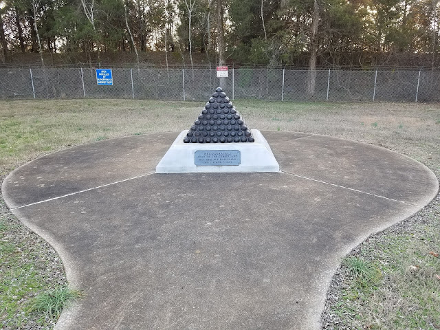
Monument marking the location of General Rosecrans headquarters during the battle

Monument to the Union artillery at the McFadden Farm
Stones River National Cemetery
Union artillery facing south near the Nashville Pike

Tuesday, July 4, 2017

9. Minute Man National Historical Park, Massachusetts


               Happy Independence Day!  Today we celebrate the anniversary of the birth of our country by sharing with you a post focused on the National Park Service unit dedicated to preserving the places associated with the beginning of the American War of Independence, Minute Man National Historical Park.
Entrance sign


BACKGROUND:

               April 19th, 1775.  Following the end of the French and Indian War, friction increased between Great Britain and her colonial possessions in North America.  A series of taxes levied on the colonies in order to repay Britain’s war debts had caused widespread protests, especially in New England which saw severe cuts to its trade and commerce as a result.  As the British government cracked down on the unrest with an increasingly heavy hand, Boston in particular became a powder keg ready to explode into open revolt.  Fearing that the Massachusetts militia, (the 18th century version of today’s National Guard) called Minute Men as it was said they could assemble at a minute’s notice, would turn on British troops, orders were given for the British garrison in Boston to march west and confiscate a stockpile of militia arms and ammunition in the town of Concord.

               In Boston, two members of the Sons of Liberty, an organization opposed to British policies in the colonies, Paul Revere and William Dawes, rode out of Boston to warn the countryside that British troops were on the march and to raise the Minute Men.  After passing through the town of Lexington, the two encountered Dr. Samuel Prescott, a fellow Patriot who was returning to Concord after visiting his fiancĂ©e.  The three rode on until coming across a mounted patrol of British soldiers.  Revere was captured, Dawes escaped but was unable to continue, leaving Prescott, who had not even originally been a member of the mission to complete the ride to Concord.  As Prescott rode on through the night, word spread to more and more towns and Minute Men began making their way toward Concord.
The site of Revere, Dawes, and Prescott's encounter with a British cavalry patrol


               Around dawn, the column of British troops marched into Lexington.  Assembled on the town green were seventy-seven militiamen under the command of Captain John Parker.  As the two forces faced each other on the village green, it first appeared as though the militia would disperse.  However, a shot was fired.  To this day it is unknown as to who fired the shot, the most likely explanation being an accidental discharge.  Both sides however believed the other to be firing on them and leveled their muskets.  After the brief exchange of fire, the militia fled leaving eight dead on the green.  The British pressed on to Concord.
Lexington Green today.  The stone in the foreground marks the site of the town's three historic meeting houses.


               Upon reaching the town, the British soldiers began searching for the cache of weapons and ammunition said to be hidden there.  Most of the supplies had already been hidden or taken to safety.  Those supplies that were found in town were burned, though this would have unintended consequences.

               To the north end of Concord, hundreds of Minute Men had assembled on a hill overlooking a bridge over the Concord river saw smoke rising from the town and believed the British to be burning homes.  The militia advanced to the bridge below as a British unit approached from the far side.  The British unexpectedly opened fire, killing two Minute Men.  The colonists returned fire.  With several of their own men now lying dead and wounded, the British fell back from the North Bridge and began marching back to Boston.  The situation by now was past the point of no return however, and more Minute Men were flooding into the area.  A short distance from Concord, the Minute Men attacked the British column in earnest and a day long running battle began on the road back to Boston.  The American War of Independence had begun.
Concord's North Bridge


THE PARK:

               Although the area around Boston is mostly built over with modern suburbs, Minute Man National Historical Park preserves a roughly five-mile-long stretch of land bordering the colonial era road that ran between Lexington and Concord.  The main section of the park is a thin ribbon extending from Interstate 95 to Old Bedford Road.  Along this stretch of preserved land are the over two century old houses of colonists who witnessed and participated in the battles of Lexington and Concord, as well as the Hartwell Tavern.  Three other areas protect the area surrounding the North Bridge, the Colonel Barret House which had been where the British had expected to find the militia’s stockpiled weapons, and The Wayside, which in addition to being an historic home dating to the time of the battle later became the home of authors Louisa May Alcott and Nathaniel Hawthorn.  The park features two visitor centers, one at the eastern entrance of the park near the Interstate, the other on the hill overlooking Concord’s North Bridge.  The eastern visitor center also features a multi-media show describing the events associated with April 19th 1775.  The main stretch of the park includes miles of trails tracing the route of the march and battle back to Boston, as well as five stones marking the graves of British soldiers who were killed during the battle.  Reenactors are a common sight at the park, and major reenactment events occur annually around the anniversary of the battle.
The main visitor center at Minute Man NHP


TRAVEL TIPS:

               While it is not part of Minute Man NHP, it is recommended for the sake of better continuity and understanding of events, to begin a visit in nearby Lexington at the village green.  The center of Lexington is now a bustling suburb and the road passing by the skirmish site is heavily trafficked.  At Lexington is the town visitor center, as well as Buckman Tavern, where Captain Parker and his men gathered prior to the approach of the British troops.  At the crossroads in front of the green is a statue of a militiaman.  While the statue is officially anonymous, it is traditionally considered to be Captain Parker.
The statue at Lexington unofficially depicting Captain Parker


               After stopping at Lexington, visitors should take the left road at the fork at the statue and follow it straight to Minute Man NHP.  Once reaching the park and stopping at the visitor center, visitors can take two methods of seeing the entirety of the park.  Those inclined to be more ambitious or physically active, can follow walking trails the entire length of the park from Fiske Hill adjacent to the Interstate all the way to Meriam’s Corners, where the first major follow-up attack by the Minute Men after Concord bridge occurred.  The other option is to hop from parking lot to parking lot by car.
A stretch of the original road on which British troops marched to Concord


               Heading west from the first visitor center prominent stops include the site of Paul Revere’s capture, which correctly takes great effort to give Dr. Prescott credit for his role in the famed “Midnight Ride,” and Hartwell Tavern, where British troops were caught in a crossfire by Minute Men at the Battle Road’s “Bloody Angle.”
Grave marker to British soldiers at the "Bloody Angle"


               Further down the road in Concord is The Wayside, home of Louisa May Alcott and Nathaniel Hawthorn, and which had connections to several other prominent authors which are celebrated at the site.  The final stop for most visitors will be Concord’s North Bridge, because while the Barrett House further down the road is preserved, it is not open to the public.  On the far side of the bridge across from the parking lot is the famed Minute Man statue, a farmer pushing aside his plow and taking up his musket to defend his liberty.
The Minute Man

Atop the hill beyond the statue is the second visitor center, located inside the Buttrick Estate.  While the mansion where the visitor center is now located was built in 1911, the property was owned by the Buttrick family since the 1600s, and one of the family Major John Buttrick was the officer who gave the order for the Minute Men to return fire at British troops at Concord Bridge.
The North Bridge visitor center at the Buttrick Estate


               The grounds of the park are open from sunrise to sunset, with the visitor centers open from 9:00am-5:00pm.  The Wayside, Hartwell Tavern, and Jacob Wittemore House, are only open from Mid-June through October, and only on specific days, so it is recommended to check the park website first to plan ahead.  The park does not have an entrance fee except for The Wayside house.  Passport stamps can be found at both visitor centers.

               We hope you have enjoyed this brief summary of Minute Man National Historic Park.   Once again, Happy Independence Day and safe travels!

ADDITIONAL PHOTOS:
Buckman Tavern in Lexington

Hartwell Tavern alongside the Battle Road

Meriam's Corners where the Minute Men conducted their first serious attack on the retreating British column

Memorial Obelisk at North Bridge.  The Minute Man statue is on the far side

The grave marker for British soldiers at North Bridge

Foundations of the historic houses of the Buttrick family across from the North Bridge visitor center