Showing posts with label Ohio. Show all posts

Monday, October 7, 2019

57. William Howard Taft National Historic Site, Ohio


               Hello!  Welcome back to our blog.  In this entry we will be making a stop at the last NPS unit dedicated to an Ohio President at William Howard Taft National Historic Site.

Entrance Sign

BACKGROUND:
               In 1857, a prominent Ohio lawyer Alphonso Taft and his wife Louise, celebrated the birth of their son William in their house in the upscale Mt. Auburn neighborhood of Cincinnati.  Following the Civil War, Alphonso would become a statesman, actively involved in the Ohio Republican Party.  When he reached adulthood, William Taft decided to follow his father into politics, embarking on a storied career and founding a political dynasty.  Taft worked his way up the ranks of the Republican party, first through the court system and then as a diplomat, gaining notoriety for his efforts to establish a new government in the Philippines following its acquisition in 1898.  After becoming good friends with Theodore Roosevelt, he was appointed Secretary of War after Roosevelt ascended to the Presidency and was anointed as his successor. 
While Taft successfully campaigned for President in 1908, he had a falling out with Roosevelt over policy, leading to Roosevelt running against him as an independent, splitting the Republican vote and allowing Democrat Thomas Woodrow Wilson to win the Presidency.  Taft retreated from the limelight following his tenure as President, until President Warren G. Harding gave him the job he had dreamed of his whole life; Chief Justice of the Supreme Court.  Taft would serve on the high court from 1921 until 1930 and is the only person to have been both President and Chief Justice.
In addition to his own career, generations of his descendants entered into politics, most notably the lineage of his son Robert Taft, one of the most prominent Senators of the 20th century, Robert Jr. who was also a Senator, and Robert III who was governor of Ohio.

The birthplace and childhood home of William Howard Taft

THE SITE:
               William Howard Taft National Historic Site is located on Auburn Avenue in the Mt. Auburn neighborhood of Cincinnati, Ohio.  The site consists of a small visitor center and the house owned by Alphonso Taft which was the birthplace and boyhood home of William Howard Taft.  The house is an original structure which has been restored on the ground floor to its appearance circa 1855-1865 when Taft was growing up at the house.  The second floor of the house contains galleries with exhibits featuring artifacts from both William Howard Taft’s career but also his father Alphonso.

The restored parlor of the Taft home.

TRAVEL TIPS:
               William Howard Taft National Historic Site is open from 8am to 4pm year-round, except on major holidays.  Ranger led tours of the Taft house are scheduled every hour on the hour.  The site is handicapped accessible and the visitor center contains a short film on the life of William Howard Taft.  Passport Stamps can be found at the front desk in the visitor center.


A second view of the house's exterior seen through the front gate.


ADDITIONAL PHOTOS:

The restored office of Alphonso Taft.

A second view of the restored parlor.

A series of gifts on display in the Taft home given to Alphonso Taft from the Russian Czar while he was serving as an ambassador.

The ceremonial key to the city of Manila given in recognition of William Howard Taft's work in the Philippines following its acquisition following the Spanish-American War.


56. Hopewell Culture National Historical Park, Ohio


               Welcome back to our blog!  In this post we are visiting an ancient American Indian site in southern Ohio famous for its burial mounds.

Entrance Sign

BACKGROUND:
               Lasting from about the year 200 B.C. to A.D. 500, the ancient American Indian people known as the “Hopewell Culture” stretched over an area along the Mississippi and Ohio River valleys.  The wide influence of these people facilitated the trade of diverse goods such as copper, silver, mica, and obsidian to the Hopewell heartland in Ohio.  These goods were then buried with the dead in elaborate earthworks spread out across the major river valleys of North America.  Because the Hopewell left no written language, modern archaeologists have only the tantalizing clues left behind by the burials and apparent astronomical alignments to help them surmise the significance of the earthworks.
               When Europeans began to settle the Midwest, the settlers paid little attention to these earthworks seeing them more as obstacles to farming.  The Smithsonian Institute conducted some of its first archaeological studies focusing on these ancient earthworks, but it was not until the beginning of the 20th century that serious study and preservation work was done.  The most promising of these earthwork sites were located in and around the town of Chillicothe in southern Ohio.  Here, five major earthworks were studied, particularly the dramatic Mound City Group.  Disaster almost befell the earthworks during World War One, when the US Army built a training camp directly over Mound City Group and it was only through direct appeals by archaeologists to the camp commandant that saved the most prominent burial mounds from destruction.  As soon as the war ended, archaeological work resumed, the earthworks at Mound City Group were restored, and in 1923 Ohio native President Warren G. Harding declared the sites around Chillicothe a National Monument under the National Park Service.

A wide view of the Mound City Group earthworks.

THE HISTORICAL PARK:
               Hopewell Culture National Historical Park is spread out over five distinct earthwork sites in and around the town of Chillicothe, Ohio.  The primary site is “Mound City Group,” just north of Chillicothe on the west bank of the Scioto River.  The visitor center is located at the entrance to Mound City Group, which was the only one of the five earthworks in the park that were restored in the early 20th Century.  The visitor center contains a small museum with artifacts from the archaeological digs and a short film.  The other earthworks (Hopewell Mound Group, Seip, and Hopeton) are open to the public, but centuries of natural erosion and later wanton destruction by farming are now barely noticeable bumps in the terrain.  The NPS has a policy of mowing the grass at the additional works in a way that accentuates the outline of the earthworks.  The fifth earthwork, High Bank Works, is not open to the public.  Visitors may walk the grounds at the four open earthwork sites with the stipulation that the earthworks are not to be stepped on.

A view of Mound 7 and the Elliptical Mound just behind it, the two most prominent of Mound City Group's burial mounds.  It was these mounds that were saved from destruction by the Army through the efforts of archaeologists to build the camp barracks around the mounds. 


TRAVEL TIPS:
               Hopewell Culture National Historical Park is roughly an hour’s drive south from Columbus, Ohio.  The park grounds are open from dawn until dusk with the visitor center open year-round with major holiday exceptions from 8:30am to 5pm.  All of the open earthwork sites can be seen within a few hours.  There are no paved trails at the earthworks so handicapped accessibility is limited.  Passport stamps can be found at the visitor center.

ADDITIONAL PHOTOS:

Examples of artifacts found within the burial mounds on display in the visitor center.

A copper bird found within Mound 7 at Mound City Group.  The artifact is the unofficial logo of the park.

A series of topographical maps with artistic embellishments illustrating the five earthworks preserved by the park.

The wooden plugs in this photo represent where wooden stakes for a structure were placed within the Mound City Group enclosure.  It is presumed that the structure was used for ceremonies, probably related to the burials. 


50. First Ladies National Historic Site, Ohio

               Hello!  Welcome back to our blog on the National Park Service.  For this post, we make another stop at a Presidential home as well as a site dedicated to their wives, the First Ladies, at First Ladies National Historic Site.

Entrance Sign

BACKGROUND:
               In the mid-1990s, a push was made in Congress to establish a repository for documents, research, and commemoration of the First Ladies of the United States.  The location chosen to host this library was the former home of a First Lady, Ida Saxton McKinley in Canton, Ohio.

The home of Ida Saxton McKinley.

               Ida Saxton grew up in Canton, Ohio, the daughter of the local newspaper owner and banker.  In 1871, she married William McKinley, a former Union Army officer who was embarking on a career in politics.  While William rose through the ranks of the Republican party, from member of the House of Representatives and Governor of Ohio, the couple’s personal lives were beset with tragedy.  Both of the McKinleys' two daughters died in childhood, while Ida McKinley suffered from Epilepsy.  While the McKinleys' owned other properties, they continued to spend the majority of their time at Ida’s childhood home, living with her sister’s family.  In 1896, William McKinley was elected the 25th President of the United States, elevating Ida to the role of First Lady, however due to her ill health most of her official duties would be passed the Second Ladies, Jennie Hobart and Edith Roosevelt the wives of McKinley’s Vice Presidents.  Tragedy once again struck the McKinley family when in 1901, the President was assassinated by an anarchist.  Afterwards her health continued to decline until her death in 1907.

THE SITE:
               While it is called First Ladies National Historic Site, most of the focus and interpretation is on the Saxton-McKinley family.  The site is a joint operation between the National Park Service and the National First Ladies Library, and consists of two buildings, the Saxton-McKinley home and a former bank building.  The Saxton-McKinley house passed out of the family’s hands during the 20th Century, and went through extensive reconstructions and remodeling until it was nearly unrecognizable until a team of preservationists acquired the house and began restoration work.  The house as it stands now has been restored to its Victorian Era appearance.
               Further down the street is the building of the former City National Bank.  This building was acquired specifically to house the archives of the National First Ladies Library.  It also functions as the site’s visitor center.

The former City National Bank building which houses the archives of the National First Ladies Library.


TRAVEL TIPS:

               First Ladies National Historic Site is located on Market Avenue in downtown Canton, Ohio.  Tours begin at the visitor center and guests are walked over to the Saxton-McKinley house.  Between the two buildings is a small parking lot and a courtyard.  There is a small admission fee.  The visitor center contains a gift shop and plays a 45-minute film on the history of the First Ladies.  The site is handicapped accessible.  Passport stamps can be found at the front desk in the visitor center, as well as directions from the site to the nearby tomb of President and Mrs. McKinley, also located in Canton.

ADDITIONAL PHOTOS:

The tomb of President William McKinley, also located in Canton.
The dining room of the restored Saxton-McKinley home, with a portrait of Ida McKinley on the wall.

An exhibit in the visitor center showcasing personal artifacts from several First Ladies.

William McKinley's office on the third floor of the Saxton-McKinley house.


Friday, August 17, 2018

Affiliated Area: Fallen Timbers Battlefield and Fort Miamis National Historic Site, Ohio

               Hello!  Welcome back to our blog.  In this post we will be visiting the second of Ohio’s two Affiliated Areas, Fallen Timbers Battlefield and Fort Miamis National Historic Site.

Entrance Sign

BACKGROUND:
               Following the American War of Independence, the situation in the Northwest Territory, the present-day states of Ohio, Michigan, Indiana, Illinois, Wisconsin, and Minnesota, was somewhat complicated.  Although this large tract of territory and been ceded to the United States, Britain continued to garrison a number of forts in the wilderness.  To complicate matters, settlers heading west into Ohio began to clash with Native Indian tribes, which were receiving clandestine military support from the British.  To deal with harassment on the frontier an army was raised in 1791 under the command of War of Independence veteran Arthur St. Clair, and marched north from Cincinnati deep into Ohio.  This army met with disaster in the Battle of Wabash, fought at present-day Fort Recovery, Ohio on the Indiana border.  St. Clair’s army was destroyed, suffering an astounding ninety-seven percent casualty rate with a total of over eight hundred dead out of a force of roughly twelve hundred.  It would be the greatest victory by Native American Indian forces over the United States in history, far larger than Custer’s famed defeat at the Battle of the Little Bighorn.
               To restore the situation, a second army was assembled under another War of Independence veteran, General “Mad” Anthony Wayne, so nicknamed for his fiery temperament.  Wayne set out in 1794 and conducted a methodical and logistically sophisticated campaign, slowly building roads and supply bases, such as the city that stills bares his name, Fort Wayne, Indiana.  American Indian forces rallied to a point along the banks of the Maumee River not far from a British post called Fort Miamis.  Wayne’s army marched to meet them.  The following battle, called Fallen Timbers after a group of trees which had been felled in the vicinity, was a decisive U.S. victory.  The Indians retreated, hoping to find aid and sanctuary at Fort Miamis.  However, while the British had allowed a large number of Canadian militia to fight alongside the Indians in battle, they barred the gates upon their defeat to Wayne.  The Indian chiefs entered into negotiations with Wayne, culminating the following year with the Treaty of Greenville, which opened the majority of Ohio to settlers, and began a sequence of events which lead to the rise of the great Indian warrior Tecumseh, the Battle of Tippecanoe in 1811, and contributed to the outbreak of the War of 1812.

The original Ohio state monument at the battlefield, depicting General Anthony Wayne, Indian commander Chief Little Turtle, and a militiaman.

THE SITE:
               Fallen Timbers Battlefield and Fort Miamis National Historic Site is located in the town of Maumee, Ohio, a suburb of Toledo.  Originally it was thought that the battle had predominantly been fought on the floodplain of the Maumee river.  Accordingly, the battle was memorialized with a small state park overlooking the river.  However, in the 1990s, archaeological surveys discovered that the battle had mostly been fought on the bluff above the river.  In the mid-2010s, a preservation effort with the cooperation of the National Park Service was begun to save the battlefield from development, particularly after a large retail shopping complex was constructed a few hundred yards away.  The preserved area of the battlefield, incorporating the original state monument, and a small section of the remaining earthworks of the British Fort Miamis located several miles away, was opened under the management of the Toledo Metroparks in 2015.

This photo taken at the battlefield displays the densely wooded terrain the battle was fought in.

TRAVEL TIPS:
               Fallen Timbers Battlefield is easily accessible, located nearby the junction of Interstate 475 and the US Route 24 freeway.  As of this writing, a visitor center has been constructed for the site and was scheduled to be operational this summer.  A trail completes of full circuit of the battlefield and connects to the original state monument using a pedestrian bridge over US Route 24.  A project to restore the battlefield to its 1794 appearance is ongoing.  The site is handicapped accessible and there is no entrance fee.  The site is open year-round, including holidays, from 7am until dusk.  The passport stamp is currently located fastened to an interpretive sign showing a map of the battlefield behind the newly constructed visitor center.

ADDITIONAL PHOTOS:

A section of the battlefield currently undergoing restoration.  The objects in the photo are plastic tubes protecting tree saplings as part of an effort to return the battlefield to its original forested appearance, as well as providing scenic camouflage for Interstate 475 bordering the park in the background. 

Located next to the original state monument is Turkey Foot Rock, which served as a prominent landmark at the time of the battle.  Behind the rock is a monument commemorating the bicentennial anniversary of the battle and listing the Native American Indian Tribes which participated in the battle.

Tuesday, April 24, 2018

30. Dayton Aviation Heritage National Historical Park, Ohio

               Hello!  Welcome back to our blog on the National Park Service.  We are back in our native Ohio at a park that showcases the origin of why our state is “The Birthplace of Aviation” at Dayton Aviation Heritage National Historical Park.

Entrance Sign and Cycle Shop visitor center.

BACKGROUND:
               On December 17th, 1903, two brothers achieved the impossible.  At Kitty Hawk, North Carolina, Wilbur and Orville Wright from Dayton Ohio succeeded in making the first flight in a modern aircraft.  While it had been possible to take to the air using balloons since the 1700s, it was the first time that a heavier-than-air powered machine had achieved flight.  The event had been the culmination of the brothers’ lifelong dream that had begun years earlier.
               The Wright Brothers had long had dreams of success.  In their hometown of Dayton, the brothers had entered into multiple business ventures, most notably a newspaper and a bicycle shop.  But it was the dream of inventing a flying machine that continued to drive them.  After their great success at Kitty Hawk, they returned to Dayton to continue their work.  Seeing the obvious entrepreneurial potential of powered flight, the brothers worked to secure patents for their aircraft and continued experimenting to perfect their airplane.  After countless test flights, crashes, rebuilds, and refinements at their rudimentary airfield at Huffman Prairie outside Dayton, the Wrights had perfected their airplane.  Although Wilbur would die young in 1909, Orville would continue on, building an aircraft factory in 1910, and remaining active in aviation until his passing in 1948.
               At the same time the Wright Brothers were working their way toward powered flight, another Dayton native was rising to prominence in the literary world.  Paul Laurence Dunbar, a friend and classmate of the Wright Brothers had been among the earliest black writers to rise to national acclaim for his poetry and other literary works, getting his start after the Wright Brothers had printed his publications in their newspaper.  This pioneering writer however, like Wilbur Wright, died tragically young in 1906.

The 1905 Wright Flyer, on display at the Wright Aviation Center within Carillon Historical Park.

THE PARK:
               Dayton Aviation Heritage National Historical Park preserves six locales associated with the Wright Brothers and Paul Laurence Dunbar in and around Dayton, Ohio.  The primary visitor center for the site is located on Dayton’s west side, housed in the building which once held the offices of the Wright Brothers printing business.  Behind the visitor center is one of the Wrights’ Bicycle shops (the Wrights operated several prior to fame and fortune, this being one of the earlier shops.  The shop they owned at the time of Kitty Hawk was purchased by Henry Ford and moved to his Greenfield Village complex in Dearborn, Michigan).  Both buildings have been restored.
               Several blocks away from the Wright Cycle Shop visitor center is the house of Paul Laurence Dunbar, which is also a State Historic Site that was incorporated into the park.  At the far west end of Dayton is the site of the Wright Airplane Factory, built in 1910.  The structure is not open to the public and is currently in the process of being restored. 
To the south of Dayton in the suburb of Oakwood are the Wright Aviation Center and Hawthorne Hill.  The Wright Aviation Center was built to house the 1905 Wright Flyer, the aircraft used by the brothers in their test flights after returning to Dayton.  It is located within Carillon Historical Park, an open-air museum dedicating to preserving historic structures and the industrial legacy of Dayton and the surrounding area.  The Wright Aviation Center also includes a replica of the original Wright Cycle Shop currently located in Dearborn, Michigan.  Nearby is Hawthorne Hill, the mansion that the Wright Brothers, along with their sister had begun building prior to Wilbur’s death.  It remained Orville’s home for the rest of his life.
The final section of the park lies to the northeast of Dayton, on the grounds of Wright-Patterson Air Force Base.  A second visitor center is located next to the memorial erected to honor the brothers in the 1940s, while nearby is Huffman Prairie, where Wilbur and Orville conducted their test flights in the 1905 Wright Flyer.  The Prairie is essentially the world’s first airfield.


The Wright Cycle Shop.

TRAVEL TIPS:
               Although Dayton Aviation Heritage National Historical Park is spread out over the Dayton area it is possible to visit the entire park in one day.  It is recommended that visitors begin at the Cycle Shop visitor center and then use the brochure map to take a driving tour of the park in the order described above.  The visitor centers at Huffman Prairie and the Cycle Shop contain the same short film on the Wrights’ activities in Dayton following the first flight at Kitty Hawk in 1903.  The different sections of the park have differing operating days and hours, with the Cycle Shop and Huffman Prairie visitor centers open 9am to 5pm year-round, closed on Monday and Tuesday in winter.  The Paul Laurence Dunbar house is open from 10am to 4pm on weekends only.  Visitors are recommended to use caution in the vicinity of Huffman Prairie as it is located adjacent to a shotgun range.
               To visit the Wright Aviation Center, visitors must go through the Carillon Historical Park, for which there are entrance fees.  The Carillon Historical Park is open from 9:30am to 5pm Monday through Saturday, and Noon to 5pm on Sundays.  To visit the Hawthorne Hill mansion, visitors must make appointments in advance.
               The visitor centers and significant historic sites are handicapped accessible.  Passport stamps can be found at the visitor centers.  For those who are interested in other aspects of aviation, it is highly recommended to visit the National Museum of the United States Air Force at nearby Wright-Patterson Air Force Base.

The memorial to the Wright Brothers near Huffman Prairie.


ADDITIONAL PHOTOS:

A view of Huffman Prairie where the Wright Brothers conducted test flights after returning to Dayton.

The front exterior of the Cycle Shop visitor center which once held the offices of the Wright Brothers' printing business.

The restored interior on the ground floor of the Wright Brothers' printing company showing the store of the local grocer complete with a mannequin shopping for goods.

The restored interior of the second floor of the Wright's printing shop.

Fragments of the original 1903 Wright Flyer which was destroyed after its final flight at Kitty Hawk, on display at the Cycle Shop visitor center.

The interior of the Wright Cycle Shop.

The House of Paul Laurence Dunbar (with front sign in need of repair).

Hawthorne Hill, the estate of Orville Wright.

The exterior of the Wright Aviation Center at Carillon Historical Park.


Thursday, February 1, 2018

23. Perry’s Victory and International Peace Memorial, Ohio


               Hello, welcome back to our blog on the National Park Service.  For our latest post, we come home to our native Ohio to visit the location of Ohio’s greatest battle, and the monument that commemorates it and our greatest peace with a foreign nation, Perry’s Victory and International Peace Memorial.


Entrance sign

BACKGROUND:
               In September of 1813, Britain and the United States were contesting control of the Great Lakes as part of the War of 1812.  Whoever controlled Lake Erie in particular, would have near unfettered dominance of the upper Great Lakes and potentially lead to the conquest of either Michigan or Ontario.  Both sides rushed to build ships suitable for the lake and on September 10th, 1813, they met in battle off South Bass Island in Lake Erie.

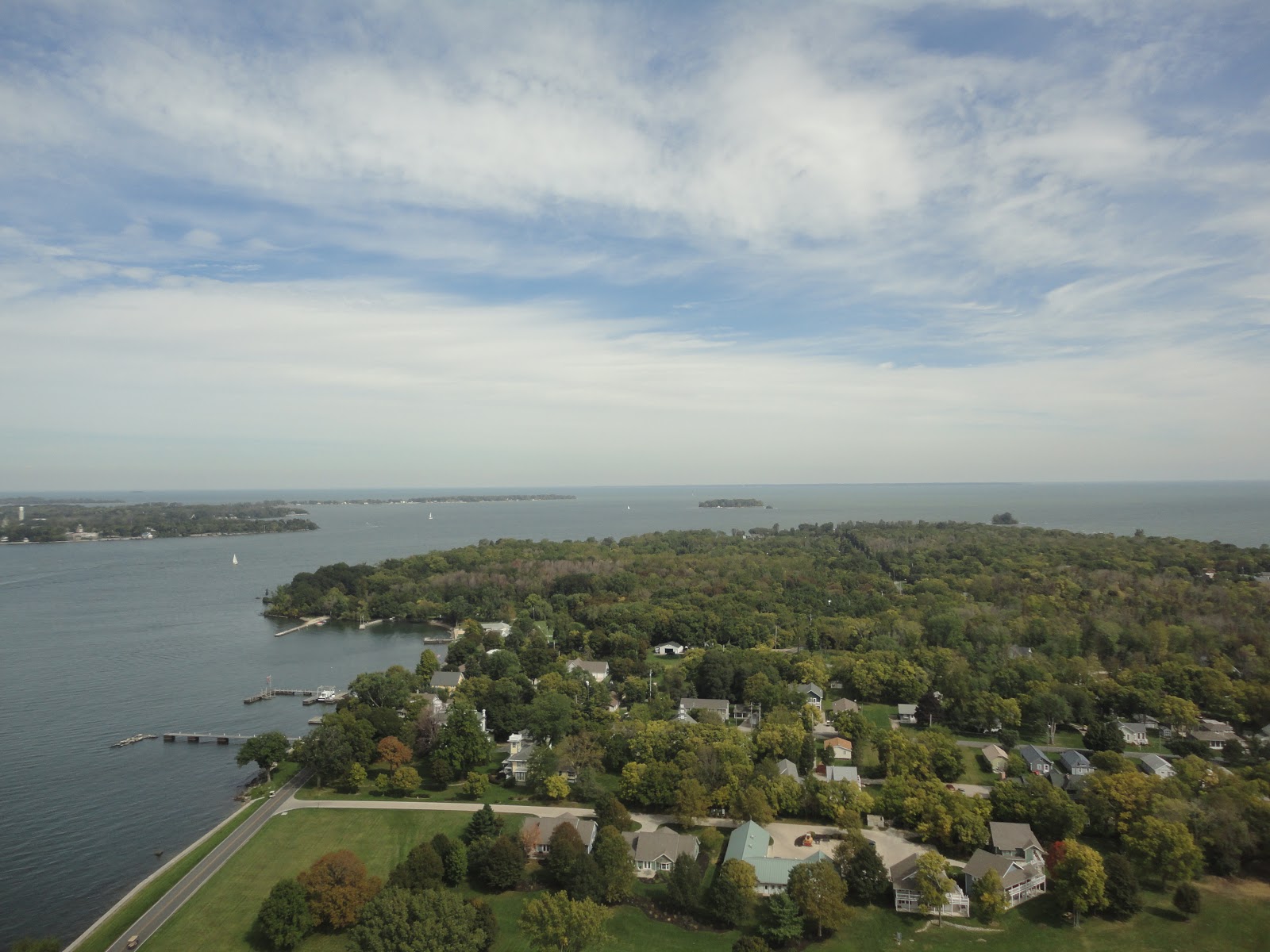
A view of the area on which the Battle of Lake Erie was fought, as seen from atop the Perry's Victory monument column.  The two squadrons engaged each other to the northwest, just beyond Rattlesnake Island, the small island in the center of the photo.  The anchorage of Put-In-Bay is seen at lower left.

               At first the British seemed to have the upper hand.  The American flagship, U.S.S. Lawrence, had become separated from the rest of the squadron and faced the entire Royal Navy force virtually alone.  Although her crew were able to dish out as much punishment as they received, the Lawrence was soon reduced to a wreck.  At this critical moment, rather than admit defeat, the American commander, Commodore Oliver Hazard Perry decided to continue the fight.  Hauling down his battle flag, emblazoned with the last words of his best friend fellow naval officer James Lawrence, “Don’t give up the ship!” Perry boarded a small boat and rowed under enemy fire to reach the rest of the U.S. squadron.  After assuming command of the U.S.S. Niagara, Perry led the squadron back into battle decisively defeating the British, capturing the entire Royal Navy squadron.


Perry's famed "Don't Give Up the Ship" battle flag, which flew above both the U.S.S. Lawrence and U.S.S. Niagara during the battle, currently on display at the U.S. Naval Academy in Annapolis, Maryland.

               A century later, to celebrate the centennial of the battle, a massive stone column was erected as a monument, not only to the American victory at the Battle of Lake Erie, but to the lasting peace forged at the war’s end which lead to the United States and Canada enjoying the longest undefended border in the world.

A view of the monument column from the memorial grounds with the flags of Canada, Great Britain, and the United States in the foreground.  Note that the U.S. flag on display is the War of 1812 fifteen stars and fifteen stripes version.

THE MEMORIAL:
               Perry’s Victory and International Peace Memorial is located on South Bass Island, more commonly known as Put-In Bay after the town centered on the island’s harbor, among the Lake Erie Islands in Ohio.  The Memorial comprises a thin strip of land across the neck of South Bass Island, upon which sits the largest Doric column in the world.  The column stands atop the site where six officers who were killed during the battle, three American and three British, were laid to rest.  Within the base of column is a small rotunda where plaques list the U.S. casualties from the Battle of Lake Erie.  Directly above the rotunda is an elevator which transports visitors to an observation platform at the very top of the monument.  The visitor center is located at the south end of the park lawn surrounding the monument.

A statue depicting Commodore Perry on display in the visitor center.  The monument column is directly behind the statue through the windows.

TRAVEL TIPS:
               In order to visit Perry’s Victory and International Peace Memorial, visitors will need to arrive on South Bass Island by either boat or aircraft.  It is recommended to take one of the several ferries from the mainland instead of a boat or plane rental.  While cars are allowed on the ferries it is generally recommended to park on the mainland and rent a golf cart (the primary mode of transportation on the island) or a bicycle.  The memorial grounds and visitor center are located on the northern edge of the town of Put-In-Bay, a popular tourist destination in the summer months filled with both restaurants and souvenir shops (replica "Don't Give Up the Ship" flags are ubiquitous).  It is highly recommended to check the memorial's schedule ahead of your visit in case special programs are planned.  If you time your visit right you may get the chance to see the actual U.S.S. Niagara which still sails the lake (albeit heavily rebuilt after two hundred years) on a call to Put-In-Bay.  The ship is based in Erie, Pennsylvania.
               The memorial and its visitor center are only open from late May through to late October, closing in the winter months.  The visitor center is open daily from 10:00am to 6:00pm in the summer, and open on the weekends in October.  A small fee is required to take the elevator to the monument’s observation deck.  Passport stamps can be found in the visitor center.

ADDITIONAL PHOTOS:


Another view of the memorial's monument column.

Artifacts from the Centennial commemorations of the Battle of Lake Erie and the dedication of the memorial on display in the visitor center.

A volunteer in period sailing garb demonstrating the use of a flintlock musket on the memorial grounds.

A marker in the rotunda of the monument column signifying the graves of six officers killed during the battle.

One of the plaques displaying the names of the men in the U.S. squadron killed and wounded during the Battle of Lake Erie in the monument column's rotunda.  The majority of the American casualties came from U.S.S. Lawrence.  (Note the writing is done in a Latin style popular on monuments in the early 1900s.  As such the letter 'U' is rendered as a 'V'.)

One of several bronze plaques in the room with the column's elevator that display the names of the remaining American sailors that participated in the battle.

A view from the column's observation platform looking north.  Middle Bass Island is at left.  The dark line along the horizon is the Canadian Pelee Island.  On a clear day the north shore of Lake Erie is just visible.