Sunday, March 25, 2018

27. Pu’ukohola Heiau National Historic Site, Hawaii

               Hello and welcome back to our blog.  In this post we return to Hawaii to examine a pivotal place in the state’s history that led to the unification of Hawaii, Pu’ukohola Heiau National Historic Site.

Entrance Sign

BACKGROUND: 
               In 1790 the Hawaiian chieftain Kamehameha had conquered several of the Hawaiian Islands in his quest to unite the nation.  However, some islands still resisted.  In order to fulfill a prophecy given to him by his aunt, Kamehameha ordered the construction of a temple to appease the Hawaiian war god on the largest island, Hawaii.  After a year of work, the temple was complete and Kamehameha was rewarded.  Armed with European cannon and firearms, Kamehameha unleashed his forces on the remaining independent islands, subduing them and becoming the first monarch of the united Kingdom of Hawaii.

The Pu'ukohola Heiau.

THE SITE:
               Pu’ukohola Heiau National Historic Site is located on the island of Hawaii, better known as the Big Island, on the northwest coast near the town of Waikoloa.  The site consists of a small area around what is called the Hill of the Whale, on which two Heiau, the Hawaiian word for temple, are built overlooking a small bay.  The larger Heiau is the eponymous Pu’ukohola Heiau, while the second, Mailekini Heiau, is located directly in front of and below Pu’ukohola Heiau.  A third temple, Hale o Kapuni Heiau, lies just off-shore underwater.  When originally constructed, the three Heiau would have been crowned with wooden structures but today only the stone bases remain.  Also on the property is the ruins of the house of John Young, a British sailor marooned on Hawaii who became a military advisor and weapons buyer for Kamehameha.
               The visitor center is a partially open-air structure near the two remaining Heiau housing a gift shop and showing several short films on the history of the site and the life of Kamehameha.  In addition the site is the terminus of the Ala Kahakai National Historic Trail, which runs along the west coast of Hawaii and connects with two other NPS units on the Big Island, Kaloko Honokohau National Historical Park, and Pu’uhonua O Honaunau National Historical Park.

The small bay below Pu'ukohola Heiau taken from the Ala Kahakai National Historic Trail..  A third Heiau at the site lies underwater.


TRAVEL TIPS:

               Pu’ukohola Heiau National Historic Site is open year-round from 8am to 4:45pm.  The site is roughly a little under an hour’s drive from Kailua Kona on Hawaii’s west coast.  Native Hawaiian cultural events are held in the summer while in the winter the aptly named Hill of the Whale is used for whale watching events.  On a clear day the island of Maui can also been seen from the site.  The site is handicapped accessible and passport stamps can be found at the visitor center.

ADDITIONAL PHOTOS:

Mailekini Heiau.  This temple was transformed into a fort by Kamehameha and armed with cannon.

The area at the shoreline below the two Heiau, seen here, was once a royal courtyard.
A second view of Pu'ukohola Heiau.


Tuesday, March 13, 2018

26. River Raisin National Battlefield Park, Michigan

Hello!  Welcome back to our blog on the NPS.  In our latest post we’ll be visiting a War of 1812 battlefield and making our first stop in the state of Michigan at River Raisin National Battlefield Park.

Entrance Sign and visitor center.

BACKGROUND:
               The War of 1812 started off badly for the United States.  Despite predictions that conquering Canada would be a swift affair, the U.S. had been embarrassed when their first invasion across the Niagara river in New York was repulsed and the British struck back by capturing Detroit in Michigan.  Suddenly the United States was forced to recover lost ground and the western shores of Lake Erie became the main theater of war.  Hoping to gain the element of surprise, American forces marched north through Ohio in winter to retake Detroit.  On January 18th, 1813 a force of roughly nine hundred U.S. troops fought off a force of Canadian militia and American Indian allies at a small settlement called Frenchtown on the banks of the River Raisin in southeast Michigan.  Several days later on January 22nd, a much larger force of British regulars, along with additional Canadians and Indian allies returned to assault Frenchtown.  The British were able to flank and rout the professional U.S. 17th Infantry regiment, inflicting mass casualties.  Kentucky militia continued to hold out along a rail fence, until receiving orders to surrender from the captured American commander.  Most of the American prisoners were marched north while the wounded were left in Frenchtown to be retrieved later.  However, the next day, before British troops returned, their Native Indian allies fell upon the town and massacred the wounded Americans.  Out of the over nine hundred U.S. troops engaged in the two battles at Frenchtown and the ensuing massacre, only thirty-three were able escape unscathed back to American lines.  The defeat badly set back the U.S. counter-offensive to retake Detroit, while the massacre at Frenchtown gave the Americans the rallying cry of, “Remember the Raisin!”

A monument opposite the park grounds commemorating the U.S. soldiers who were killed in the battle and massacre at Frenchtown.

THE BATTLEFIELD PARK:
River Raisin National Battlefield Park was originally a Michigan state historic site until becoming a unit of the National Park Service in 2009.  The park currently preserves a tract of land at the corner of Elm Street and North Dixie Highway along the north bank of the River Raisin.  The majority of the property is open fields where the British force attacked across during the second battle on January 22nd, 1813.  No original structures from the Frenchtown settlement remain, their locations built over by modern homes along Elm Street, however a rail fence where the Kentucky militia made their last stand was erected on the original spot.  A trail circles the edge of the battlefield.

The reconstructed rail fence where the Kentucky militiamen fought off several attacks by British regulars.  The British would have been advancing from the right of the photo.

TRAVEL TIPS:
               River Raisin National Battlefield Park is located in the present-day town of Monroe, Michigan, which absorbed the Frenchtown settlement, a roughly twenty-minute drive north from Toledo, Ohio.  The park is open from 9am to 5pm year-round with holiday exceptions.  For those interested in a more authentic experience, it is recommended to visit in the winter.  In addition, battle reenactments are conducted around the anniversary of the battle in January.  The visitor center contains a short film and exhibits featuring artifacts from the battle.  The park is handicapped accessible and passport stamps can  be found at the front desk in the visitor center.

ADDITIONAL PHOTOS:

A picnic shelter and historical markers behind the visitor center on the ground where the U.S. 17th Infantry Regiment camped prior to the battle.

Two mannequins in the visitor center displaying the uniforms of U.S. regulars (right) and militia (left).

A second mannequin display depicting the appearance of British soldiers at River Raisin, from left to right, Canadian militia, an artilleryman with a light cannon mounted on a sled for traversing through snow, and a British infantryman.


Thursday, March 1, 2018

25. George Washington Birthplace National Monument, Virginia

               Hello, and welcome once again to our blog on the National Park Service.  In this installment we visit the birthplace of the father of our country, George Washington Birthplace National Monument.

Entrance Sign

BACKGROUND:
               In 1664, a man named John Washington settled on a large tract of property he had purchased at the junction of Popes Creek and the Potomac River in the English colony of Virginia.  Over the next two generations his family prospered farming tobacco.  In 1732, on the very same land, his Great-Grandson, George Washington was born.  From this unassuming farm in colonial Virginia, George Washington would have a disproportionate impact on history.  His actions as a young militia officer in 1754 caused the French and Indian War, a conflict which was arguably the first ‘world war.’  This would lead a chain reaction of events which caused Britain’s American colonies to rise up in revolt, once again thrusting Washington into the spotlight as the leader of America’s armies in the War of Independence.  After winning the seemingly impossible victory, Washington was called on once again to lead his country as the first President of the United States, cementing his legacy as the “Father of the Country.”

               As the years passed there were many attempts the memorialize Washington’s birthplace, but it was not until the 1920s when a private organization backed by industrialist John D. Rockefeller succeeded in acquiring the land for preservation efforts.  A replica of the house in which Washington was born was built, and the land was designated as a National Monument in 1930.

The Memorial House at left and the colonial kitchen at right.

THE MONUMENT:
               George Washington Birthplace National Monument consists of a large area of land at the confluence of Popes Creek and the Potomac River in the Tidewater region of Virginia.  The centerpiece of the Monument is the replica of the house in which Washington was born, known as the Memorial House.  When it was constructed in 1930, it was presumed that the Memorial House was standing on the same location of the original structure.  However, subsequent investigations have revealed that information to be incorrect, and the outline the true birthplace home is marked on the ground not far from the Memorial House.  (However, Park Rangers at the Monument informed the authors that further archaeological research has suggested that this site may also be inaccurate.)  Adjacent to the Memorial House is a colonial garden where traditional herbs are grown.  The grounds surrounding the Memorial House are still a working farm, providing visitors with a first-hand perspective of what the Washington farm would have looked and how it operated at the time of Washington’s birth.  A small distance up the road, away from the visitor center and colonial farm, is the Washington family burial plot.

The Washington family burial plot, including the grave of George Washington's Great-Grandfather John Washington.

TRAVEL TIPS:
               George Washington Birthplace National Monument is located roughly an hour and twenty minutes’ drive northeast from Richmond Virginia, and one and a half hours’ drive south from the District of Columbia.  The Monument is open from 9am to 5pm, shortened to 10am to 5pm from January to March, and is open year-round with holiday exceptions.  Ranger led tours of the ground and the Memorial House occur every hour from 10am to 4pm, and the visitor center has a short film.  The Memorial House is not handicapped accessible.   Passport stamps can be found in the visitor center.

ADDITIONAL PHOTOS:
A memorial obelisk at the roundabout at the entrance to the Monument, first erected in 1896.

The outline of the presumed actual birthplace home of George Washington.

The colonial garden adjacent to the Memorial House.

The interior entry hall of the Memorial House.

The grounds of the Monument, including some rebuilt colonial farm buildings.

The confluence of Popes Creek and the Potomac River.  The Maryland shore is on the far side.


Thursday, February 15, 2018

24. Monocacy National Battlefield, Maryland


               Hello and welcome back to our blog.  In this post, we return to western Maryland to another Civil War locale, Monocacy National Battlefield.

Entrance Sign

BACKGROUND:
               In the summer of 1864, with General Ulysses S. Grant continuing to push to take the Confederate capital of Richmond, the Confederates hoped to turn the tables on the Union by risking a bold lightning attack on the now lightly defended District of Columbia.  A Confederate army under the command of Jubal Early, swept out of the Shenandoah Valley to attack the national capital from the northwest.  Most of the garrison of Washington D.C. had been stripped from the city’s fortifications and sent to the front, leaving the capital dangerously unguarded.  As Early’s army came over the mountains of western Maryland, panic gripped the Union command as they desperately moved to counter the threat.  A small force cobbled together from available units was put under the command of Union General Lew Wallace, who would gain post-war fame as the author of the epic novel Ben-Hur, assembled ready to stall the Confederates along the banks of the Monocacy river south of the town of Frederick, Maryland.
Personal items belonging to General Lew Wallace, on display in the visitor center.

               On the morning of July 9th, 1864, the Confederates marched south from Frederick to seize two bridges, one a vital railroad bridge, across the Monocacy river on the road to Washington.  Union troops skirmished north of the river before falling back across the river and burning the two bridges to prevent their use by the Confederates.  However, Confederate cavalry were able to find a shallow crossing to the west of the bridges and forded the river.  Fortunately for the Union, they detected the Confederates and ambushed them, forcing them back.  More Confederates arrived pushing the Union troops further back and threatening to flank them.  At this point, Wallace ordered his men to retreat.  While the Union had been defeated, Wallace’s scratch force had accomplished their mission of buying time for Union reinforcements to secure Washington.
The modern road bridge over the Monocacy river at the same location as the original covered bridge that was burned by Union troops during the battle.

               The Monocacy battlefield lay mostly forgotten until a bill for its creation as a National Park Service unit passed Congress in 1934.  Even then, the battlefield sat there mostly empty until the 1970s when a more active campaign to preserve the area was waged following the decision to construct Interstate 270 right across the middle of the battlefield.

THE BATTLEFIELD:
A view of the northern half of the battlefield from the visitor center.

               Monocacy National Battlefield lies at the southern edge of the town of Frederick, Maryland, on both the north and south banks of the Monocacy river.  The area along the north bank has been encroached upon the city development, but the area around the southern bank retains the rural look the area had in 1864.  The battlefield preserves several historic houses that existed on the land at the time of the battle, as well as a handful of monuments erected following the war.  The railroad line and the road to Washington D.C. still cross the battlefield in the exact same locations as in 1864.  The park also contains several trails across the battlefield, and the visitor center is located on the northern edge of the battlefield just off of Maryland Route 355.  The visitor center contains exhibits and artifacts from the battle as well as a topographical light-board which demonstrates the positions of the armies during the course of the battle.
 
A photo of the topographical light board in the visitor center.  The red lights represent Confederate units, blue Union.

TRAVEL TIPS:

               Monocacy National Battlefield is open year-round with holiday exceptions from 9am to 5pm.  The battlefield is within a short drive from the nearby NPS units of Antietam NB and Harpers Ferry NHP, and is roughly a little over an hour’s drive outside of Washington D.C.  The visitor center and some of the trails are handicapped accessible.  Passport stamps can be found in the visitor center.

ADDITIONAL PHOTOS:


The monument at the battlefield to Union troops from Pennsylvania.

The Thomas Farm at the center of the battlefield's southern half where most of the fighting took place.

A view from the Thomas farm looking west in the direction from which the Confederates attacked.

The Worthington House, near the western edge of the battlefield.  Confederate Cavalry forded to the river to the rear of the house and were ambushed by Union troops in the vicinity of the house.

Thursday, February 1, 2018

23. Perry’s Victory and International Peace Memorial, Ohio


               Hello, welcome back to our blog on the National Park Service.  For our latest post, we come home to our native Ohio to visit the location of Ohio’s greatest battle, and the monument that commemorates it and our greatest peace with a foreign nation, Perry’s Victory and International Peace Memorial.


Entrance sign

BACKGROUND:
               In September of 1813, Britain and the United States were contesting control of the Great Lakes as part of the War of 1812.  Whoever controlled Lake Erie in particular, would have near unfettered dominance of the upper Great Lakes and potentially lead to the conquest of either Michigan or Ontario.  Both sides rushed to build ships suitable for the lake and on September 10th, 1813, they met in battle off South Bass Island in Lake Erie.

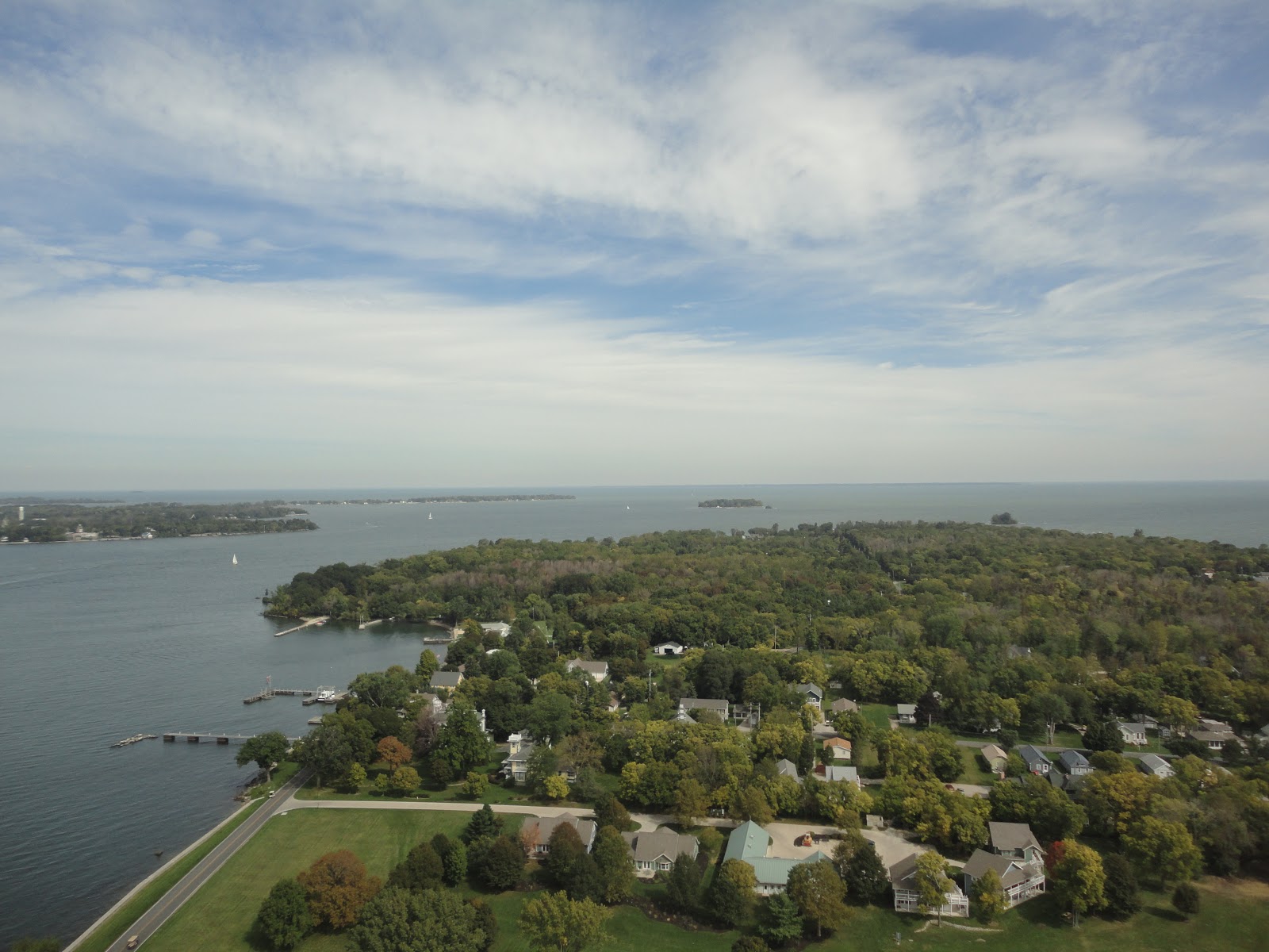
A view of the area on which the Battle of Lake Erie was fought, as seen from atop the Perry's Victory monument column.  The two squadrons engaged each other to the northwest, just beyond Rattlesnake Island, the small island in the center of the photo.  The anchorage of Put-In-Bay is seen at lower left.

               At first the British seemed to have the upper hand.  The American flagship, U.S.S. Lawrence, had become separated from the rest of the squadron and faced the entire Royal Navy force virtually alone.  Although her crew were able to dish out as much punishment as they received, the Lawrence was soon reduced to a wreck.  At this critical moment, rather than admit defeat, the American commander, Commodore Oliver Hazard Perry decided to continue the fight.  Hauling down his battle flag, emblazoned with the last words of his best friend fellow naval officer James Lawrence, “Don’t give up the ship!” Perry boarded a small boat and rowed under enemy fire to reach the rest of the U.S. squadron.  After assuming command of the U.S.S. Niagara, Perry led the squadron back into battle decisively defeating the British, capturing the entire Royal Navy squadron.


Perry's famed "Don't Give Up the Ship" battle flag, which flew above both the U.S.S. Lawrence and U.S.S. Niagara during the battle, currently on display at the U.S. Naval Academy in Annapolis, Maryland.

               A century later, to celebrate the centennial of the battle, a massive stone column was erected as a monument, not only to the American victory at the Battle of Lake Erie, but to the lasting peace forged at the war’s end which lead to the United States and Canada enjoying the longest undefended border in the world.

A view of the monument column from the memorial grounds with the flags of Canada, Great Britain, and the United States in the foreground.  Note that the U.S. flag on display is the War of 1812 fifteen stars and fifteen stripes version.

THE MEMORIAL:
               Perry’s Victory and International Peace Memorial is located on South Bass Island, more commonly known as Put-In Bay after the town centered on the island’s harbor, among the Lake Erie Islands in Ohio.  The Memorial comprises a thin strip of land across the neck of South Bass Island, upon which sits the largest Doric column in the world.  The column stands atop the site where six officers who were killed during the battle, three American and three British, were laid to rest.  Within the base of column is a small rotunda where plaques list the U.S. casualties from the Battle of Lake Erie.  Directly above the rotunda is an elevator which transports visitors to an observation platform at the very top of the monument.  The visitor center is located at the south end of the park lawn surrounding the monument.

A statue depicting Commodore Perry on display in the visitor center.  The monument column is directly behind the statue through the windows.

TRAVEL TIPS:
               In order to visit Perry’s Victory and International Peace Memorial, visitors will need to arrive on South Bass Island by either boat or aircraft.  It is recommended to take one of the several ferries from the mainland instead of a boat or plane rental.  While cars are allowed on the ferries it is generally recommended to park on the mainland and rent a golf cart (the primary mode of transportation on the island) or a bicycle.  The memorial grounds and visitor center are located on the northern edge of the town of Put-In-Bay, a popular tourist destination in the summer months filled with both restaurants and souvenir shops (replica "Don't Give Up the Ship" flags are ubiquitous).  It is highly recommended to check the memorial's schedule ahead of your visit in case special programs are planned.  If you time your visit right you may get the chance to see the actual U.S.S. Niagara which still sails the lake (albeit heavily rebuilt after two hundred years) on a call to Put-In-Bay.  The ship is based in Erie, Pennsylvania.
               The memorial and its visitor center are only open from late May through to late October, closing in the winter months.  The visitor center is open daily from 10:00am to 6:00pm in the summer, and open on the weekends in October.  A small fee is required to take the elevator to the monument’s observation deck.  Passport stamps can be found in the visitor center.

ADDITIONAL PHOTOS:


Another view of the memorial's monument column.

Artifacts from the Centennial commemorations of the Battle of Lake Erie and the dedication of the memorial on display in the visitor center.

A volunteer in period sailing garb demonstrating the use of a flintlock musket on the memorial grounds.

A marker in the rotunda of the monument column signifying the graves of six officers killed during the battle.

One of the plaques displaying the names of the men in the U.S. squadron killed and wounded during the Battle of Lake Erie in the monument column's rotunda.  The majority of the American casualties came from U.S.S. Lawrence.  (Note the writing is done in a Latin style popular on monuments in the early 1900s.  As such the letter 'U' is rendered as a 'V'.)

One of several bronze plaques in the room with the column's elevator that display the names of the remaining American sailors that participated in the battle.

A view from the column's observation platform looking north.  Middle Bass Island is at left.  The dark line along the horizon is the Canadian Pelee Island.  On a clear day the north shore of Lake Erie is just visible.