Wednesday, January 17, 2018

Affiliated Area: Touro Synagogue National Historic Site, Rhode Island


               Hello and welcome back to our blog on the National Park Service.  In this latest post, we look at our second “Affiliated Area” to the NPS, the Touro Synagogue National Historic Site in Newport, Rhode Island.

 
The Touro Synagogue National Historic Site.

BACKGROUND:

               Today Newport, Rhode Island, is best known for its famed Gilded Age mansions.  However, in its early history it was one of the country’s foremost thriving seaports.  As a result of its international shipping industry, and Rhode Island’s colonial charter giving all its citizens the protection to their right of freedom of religion, the town attracted a wide array of ethnic and religious groups and became the location of one of the United States’ oldest Jewish congregations.

               The synagogue was constructed in 1763 for Newport’s small but well established Jewish population.  Following depredations inflicted on Newport during the American War of Independence, the congregation dwindled and struggled to survive.  For long stretches the synagogue was closed during the 1800s, often rumored to be a stop along the Underground Railroad.  The synagogue was restored in the 1880s and remains an active congregation to this day.  The Touro Synagogue was designated a National Historic Site in 1946, but as it remains a privately-owned house of worship it is only an Affiliated Area of the National Park Service and not an official unit.

 
The interior of the synagogue.

THE SITE:

               The Touro Synagogue National Historic Site consists of the synagogue, a small park on its grounds, and the Ambassador John Loeb Jr. visitor center.  The synagogue is architecturally significant, contains a prized four-hundred-year-old copy of the Torah, and is the oldest synagogue in the United States.  The Loeb visitor center contains a short film on the history of the synagogue and exhibits on the Newport congregation and prominent Jewish Americans.

 
The park lawn in front of the synagogue and the rear of the Loeb visitor center.

TRAVEL TIPS:

               Touro Synagogue National Historic Site is located in the historic center of Newport Rhode Island at the intersection of Touro and Spring streets.  The historic section of Newport contains very narrow streets and parking is limited.  It is recommended that once visitors find a suitable parking lot that you then walk to the synagogue.  Fortunately, the center of Newport is compact and easily walkable.  The Touro Synagogue NHS is open year-round, with varying hours depending on the season, with tours taking place every half hour typically between 12:00pm and 1:30pm, except on the Sabbath and Jewish holidays.  The visitor center is open longer, usually from 11:30am to 2:30pm, with extended hours during the summer.  The site is handicapped accessible.  A NPS passport stamp can be found at the front desk.

Friday, January 5, 2018

22. Hawaii Volcanoes National Park, Hawaii

               Hello and welcome back to our blog.  In this post we make our second visit to one of the big 59 National Parks, and our first visit to the nation’s 50th State as we travel to Hawaii Volcanoes National Park!

Entrance Sign

BACKGROUND:
               The Hawaiian Islands are the product of millions of years of geological activity.  Located in the middle of the Pacific Ocean, the islands were created through volcanic eruptions as the Pacific tectonic plate gradually moved over what is known as a ‘hot spot’, a weak area in the Earth’s crust.  At these hot spots, volcanic eruptions are frequent, and in the case of Hawaii, created the entire island chain as the hot spot built up volcano after volcano.  The hot spot in the Pacific plate currently resides under the largest of the Hawaiian Islands, the namesake of the island chain, better known simply as the Big Island.
               The geologic properties of the Pacific hot spot have led Hawaii to be the home of the world’s most active volcanoes, in particular Kilauea, which has been erupting continuously since 1983, and at the time of this writing, is erupting in two places at the same time.  The constant eruptions on the island led the Ancient Native Hawaiians to believe it was home to the Polynesian fire goddess Pele, and the volcanoes held a deep religious significance.  The lava spewed forth from the volcanoes continues to add rock and landmass to the island of Hawaii every year.

Kilauea volcano crater.

               To recognize the uniqueness of the volcanic landscape, the area surrounding Kilauea, the larger Mauna Loa volcano, and Haleakala on the island of Maui were designated Hawaii National Park in 1916.  Later in 1961, Haleakala was split off to create its own National Park, with the park lands on the Big Island re-designated Hawaii Volcanoes National Park.

THE PARK:
               Hawaii Volcanoes National Park surrounds the peak of Kilauea volcano and a large area down its southwest flank extending to the island’s coastline.  The park also stretches up over the top of Mount Mauna Loa, the second tallest mountain on the island and largest mountain landmass in the world.  A section of tropical rain forest near the volcanoes is also preserved as a wilderness.

Mount Mauna Loa, which overlooks Kilauea.  Note the thin line of snow atop the summit.

               The Park is centered on the summit of Kilauea volcano.  At the summit is the volcano’s primary crater, several miles wide, at the center of which is a further two craters, the smallest of these two contains a lake of lava in constant eruption since 2008.  There are two visitor centers on the crater rim, the primary visitor center near the park entrance, and the Thomas Jagger Museum which overlooks the crater and is home to an observatory of the U.S. Geological Survey.  A road once circled the entirety of Kilauea crater, but the southern half of the road and a zone downwind of the summit has been closed for the duration of the current eruption due to safety concerns.  Also around the summit crater is the Volcano House, a hotel lodge with views of Kilauea, and the Kilauea Military Camp, a recreation area reserved for Military personnel.

The U.S. Geological Survey observatory which monitors Kilauea from the Jagger Museum.

               To the east is Kilauea’s smaller neighbor, Kilauea Iki crater, and the Thurston Lava Tube, a cave cut through the rock by a lava flow.  From there, meandering southeast, is Chain of Craters Road, which passes by a series of craters left by various eruptions in Kilauea’s East Rift Zone.  The road continues across a vast lava field and down a massive escarpment toward the ocean, terminating on the coast at the famed rock formation called the Holei Sea Arch.  The road once connected with a seaside highway, but the road was cut by lava flows in 1987 and remained closed ever since.  The source of these lava flows is Pu’u’O’o, a volcanic cone which has been erupting continuously since 1983, the world’s longest recorded eruption.

The Holei Sea Arch.

TRAVEL TIPS:
               Hawaii Volcanoes National Park is a roughly half-hour drive south from the city of Hilo, the island of Hawaii’s largest population center, and an hour and a half from Kailua-Kona on the island’s west coast.  The park is open twenty-four hours a day year-round including holidays.  The main visitor center is open from 9am to 5pm, and the Jagger Museum from 10am to 8pm.
               How visitors explore Hawaii Volcanoes National Park will be a matter of personal preference.  It is recommended that visitors budget an entire day to see both visitor centers and the length of Chain of Craters Road.  Nighttime viewing of Kilauea crater from the Jagger Museum is a popular attraction, though parking at the museum may be restricted necessitating a hike from other nearby parking lots.  There are similar parking restrictions at the Thurston Lava Tube.  There are restaurants within the Volcano House open to the public for lunch and dinner.

Kilauea volcano at night seen from the Jagger Museum.

While it is prohibited to visit the Pu’u’O’o Lava cone on foot, it can be seen via helicopter rides, and the lava flows from this peak can be seen up close, however a great deal of hiking will likely be necessary to find an active flow (as one Park Ranger told us, “If the lava doesn’t kill you the hike will”).  The park has two established campgrounds.  The southern area of the park contains several sites for backcountry camping.  Mount Mauna Loa, at over 13,000 feet in height, can also be climbed but only by prepared and experienced climbers.  Climate conditions at Kilauea Crater may at times also be moderately chilly.  Visitors are advised to take heed of all warning signs due to the inherent danger of the terrain. 
There are gift shops located in both visitor centers.  The primary visitor center has a short film while the Jagger museum displays feeds of recent seismic data from the volcano.  Some areas of the Park are handicapped accessible, however most trails are not.  Passport stamps can be found at the primary visitor center and the Jagger Museum.


ADDITIONAL PHOTOS:

Kilauea Iki crater which last erupted in 1959.  The gray line across the crater floor is a hiking trail.
The original Volcano House, near the visitor center, which is now an art gallery.

A steam vent near the crater rim.

The edge of Kilauea crater known as Steaming Bluff from the numerous steam vents along the crater rim.

Kilauea crater in the daytime.


The area known as Sulphur Banks (note British style spelling), created by sulfur vents from deep within the volcano.

A dangerous example of what happens when visitors do not heed warning signs.  This vent at Sulphur Banks was created when a visitor stepped off the boardwalk and broke through the unstable ground, resulting in serious burns.

Volcano House lodge.

Visitors pass through the Thurston Lava Tube.
The area just off Chain of Craters Road with the Mauna Ulu volcanic cone in the background.  In the foreground is a fissure where lava erupted in 1969.

A close up photo of rock from the 1969 fissure eruption showing smooth multicolored volcanic glass.

Chain of Craters Road as it passes over hardened lava flow rock.

A view from Chain of Craters Road looking down the escarpment towards the ocean.  The black discoloration on the plain below is the lava rock flows from the Pu'u'O'o lava vent which has been continuously erupting since 1983.

The road block which cuts off Crater Rim Drive which once circled Kilauea crater.  Mauna Loa is in the background.

A sample of cooled lava rock known as Pele's hair for its stringy hair-like appearance, formed as lava cooled in small strands in mid-air during an eruption.


An example of the lush tropical rain forests that surround Kilauea above ground at the Thurston Lava Tube

Snow capped Mauna Kea, the tallest mountain on Hawaii, seen from the Jagger Museum.  While it is not a part of the park, it is also a dormant volcano.

A view looking back at the escarpment from Chain of Craters Road near the coast.

The rocky coastline created by Pu'u'O'o lava cone looking northeast from the Holei Sea Arch.  Park Ranger estimate that the volcano has added roughly over five-hundred acres of land to the Big Island since it began erupting in 1983.

The Island of Hawaii's famed Black Sand Beach.  While this is not a part of Hawaii Volcanoes National Park, the same volcanic forces at work today are responsible for the beach's appearance.

Another view of Kilauea Crater as seen from the overlook at the Volcano House.  The Jagger Museum is located on the high ground on the crater rim in the distance.


Friday, December 15, 2017

21. Adams National Historical Park, Massachusetts


               Hello!  Welcome back to our blog.  We’ll be continuing our swing through the Northeast in this post with a trip to the home of not one, but two U.S. Presidents, John Adams and his son John Quincy Adams at Adams National Historical Park.
 
Entrance Sign for the Old House at Peace field

BACKGROUND:

               Born in 1735, John Adams would go on to prominence as one of the foremost Founding Fathers of the United States.  From being the man who defended British soldiers after the Boston Massacre, to becoming the leading voice and driving force in the Continental Congress for the cause of American Independence, John Adams was intricately involved with the creation of the country.  Alongside him in these endeavors was his formidable wife, Abigail, and his son, John Quincy Adams, who followed in his father’s footsteps as a statesman.

               Following his return from abroad as an ambassador for the newly independent United States, John and Abigail purchased a large homestead in Quincy, Massachusetts, not far from their original homestead which had been the birthplace of both John and John Quincy.  Their new estate, called ‘Peace field,’ would be the home of the Adams family for over a century, as John, and then John Quincy both ascended to the nation's highest office as the second and sixth Presidents.

The "Old House" at Peace field, the Adams' family estate

THE PARK:

               Adams National Historical Park is located in the highly developed Boston suburb of Quincy, Massachusetts.  The park consists of two main sections and a visitor center.  The visitor center is located within and office complex building in the center of Quincy.  From the visitor center, guests will be transported by trolley to first the site of the birthplace homes of John and John Quincy Adams, and then finally the Peace field mansion.


One of the Adams NHP trolleys.

               The first park section consists of two 18th century homes, the birthplaces of both Presidents.  The older of the two houses was built by John Adams’s father, also named John Adams, usually called Deacon John due to his clerical position.  The second home was gifted to John Adams by his father, and it was where John and Abigail raised their children and lived during the American War of Independence.  Both homes, though they have undergone some minor restoration and preservation processes, are the original structures.
The home of Deacon John, birthplace of Founding Father John Adams

               The second section of the park is the “Old House” or “Peace field” estate.  Purchased by John and Abigail Adams in 1788, the original property once had 75 acres.  Today only a small section around the mansion, library, and carriage house remain.  The house, like the birthplace houses is completely original.  The interior has been unaltered since at least 1927 and all of the artifacts inside are original to the Adams family as the house was donated straight from family ownership to the National Park Service in 1946.  In the rear of the mansion is the Stone Library, built by John Quincy Adams son, Charles Francis Adams, to contain his father’s large collection of books and is considered by some to be the first Presidential Library.

The Stone Library and gardens behind the Old House

TRAVEL TIPS:

               Visitors should be warned that access to the Adams National Historic Park is somewhat restrictive.  In order to visit either the birthplace houses or the Peace field mansion one must go on the guided trolley tour, which usually has a duration of two and a half hours.  Getting to the visitor center can also be difficult as Quincy is a very built up area with heavy traffic and many one-way roads.  The houses are not handicapped accessible and photography is prohibited in the interiors.  The visitor center opens at 9:00am and closes at 5:00pm in the summer, with the trolley tours departing every half hour starting at 9:15am.  While the visitor center is open during the winter, both house sites are closed.  There is a parking garage attached to the rear of the office complex where the visitor center is located.  The only restrooms at the site are located within the visitor center.  Passport stamps are to be found at the front desk.

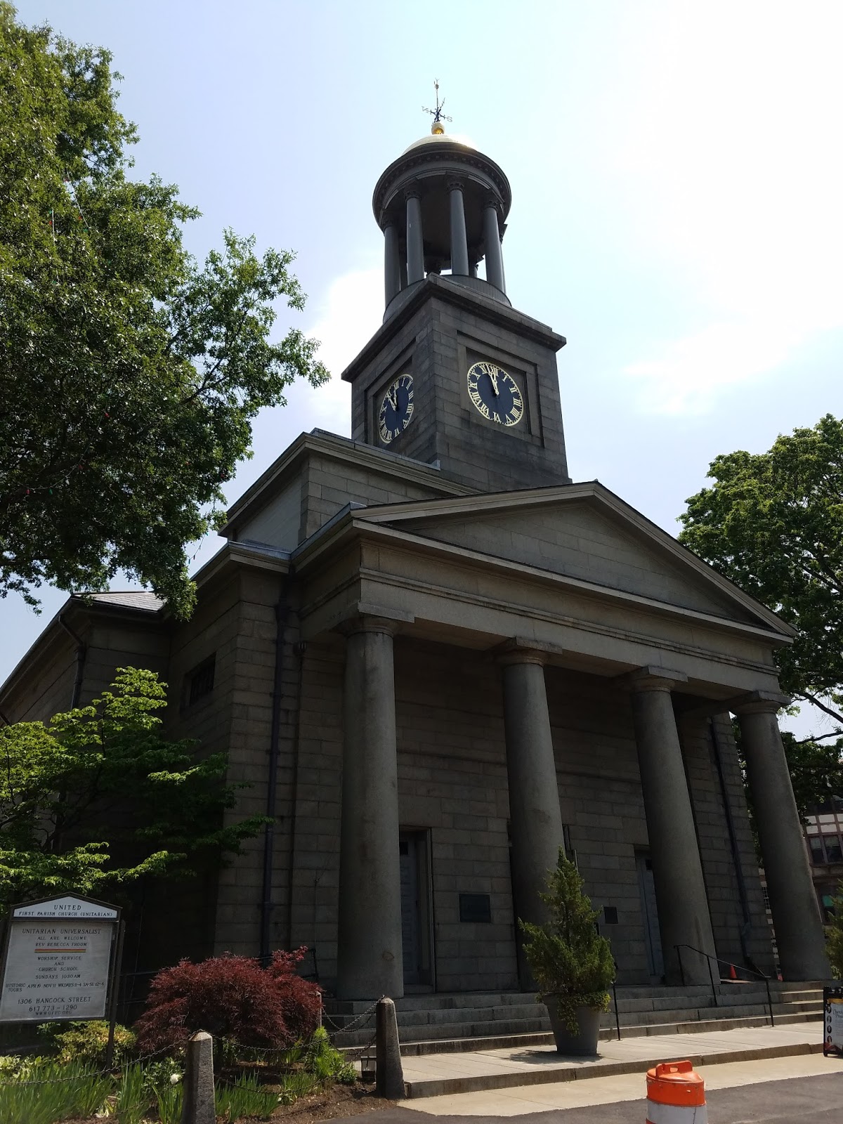
               It is recommended that after finishing your tour, to cross the street to visit the United First Parish Church, which is the burial site of both Presidents and their first ladies.  The tombs are in the basement of the church in a special vault.  There is no fee to enter the church, though a donation is recommended, and guided tours are available.
The tombs of John and Abigail Adams
ADDITIONAL PHOTOS:
The home of John and Abigail Adams and birthplace of John Quincy Adams

The carriage house at Peace field

The United First Parish Church

Tombs of John Quincy and Louisa Adams

Tuesday, November 14, 2017

20. Maggie L. Walker National Historic Site, Virginia


               Hello!  Welcome back to our blog!  In this post we return to Virginia, to visit the home of an early Civil Rights leader at Maggie L. Walker National Historic Site.
Entrance sign

BACKGROUND:
               Maggie L. Walker was born in the aftermath of the Civil War in the former Confederate capital of Richmond, Virginia, the child of former black slave and a white Confederate soldier.  Her experiences growing up in the era of segregation and Jim Crow laws would lead her to become an early Civil Rights activist.
               Her first foray into activism came as a teenager when the city of Richmond denied the city’s black high school graduates a graduation ceremony.  Although the effort to secure a ceremony for herself and her fellow classmates failed it would be the start of a long activist career.
               Throughout the late 1800s her stature within Richmond’s Black community grew as she rose through the ranks of the charitable organization known as the Independent Order of St. Luke.  Believing that economic power would eventually be the way to defeat Jim Crow laws, she championed black businesses and established the St. Luke Penny Savings Bank, becoming the first woman bank president.  Her activism would continue until her death in 1934 due to complications from diabetes.

Maggie L. Walker's bedroom on the second floor of the Walker home, where she passed away in 1934.

THE SITE: 
Maggie L. Walker National Historic Site preserves the home of Maggie L. Walker, and a block of houses known as “Quality Row,” an affluent area of Richmond’s historically black Jackson Ward neighborhood.  The Walker house remained in the possession of Maggie L. Walker’s decedents until the 1970s, when it was donated to the National Park Service.  The Walker home was kept as much as possible to the way it appeared in the early 1900s and many of the items in the home are original artifacts.  The adjacent houses along “Quality Row” now house the park visitor center, exhibits, and offices, and their external facades have been restored to their 1920s appearance.

The Walker house (center left) and a preserved stretch of "Quality Row."

TRAVEL TIPS:
               Maggie L. Walker National Historical Site is located at the corner of W. Leigh and 2nd Street in the Jackson Ward neighborhood on the northern edge of downtown Richmond, Virginia.  The site is open year-round, with holiday exceptions, from 9am to 5pm except on Sunday and Monday, and closing at 4:30pm from November through February.  It is recommended to visit during the summer as parking in the area may be difficult to find during weekdays due to the proximity to downtown and some walking may be necessary.  It is also recommended to view the short film at the visitor center before proceeding with a tour.  Tours of the Walker home are given on a first-come first serve basis and run for approximately an hour.  The Walker home is only partially handicapped accessible.  Passport stamps can be found in the visitor center.

ADDITIONAL PHOTOS:
A second view of the houses along "Quality Row."

The courtyard behind the Walker home that includes a mural of Maggie L. Walker.

The interior of the Walker home.

Tuesday, October 31, 2017

19. Fort Stanwix National Monument, New York


               Welcome back to our blog on the National Park Service.  For our latest post, we will be traveling to upstate New York to visit the site of an important crossroads of early American history, Fort Stanwix National Monument.

Entrance Sign, with the fort in the background

BACKGROUND:

               Prior to European settlement, the small stretch of land between the Mohawk River and Wood Creek in upstate New York was an important link for Indian Tribes known as the Oneida Carrying Place, where tribes used the portage between rivers to transport goods from the Atlantic coast to Lake Ontario.  This highway was also the northern gap in the Appalachian Mountains, and the location’s strategic significance was not lost on European powers as they expanded their territories westward.
The Monument visitor center, with a replica American Indian canoe of the type used to transport goods to the portage known as the Oneida Carrying Place
               During the French and Indian War, several British forts at the Oneida Carrying Place were destroyed by the French.  In order to maintain a hold on the portage, British General John Stanwix ordered the construction of a new replacement fort.  The fort was named Stanwix in his honor and held the gap between the rivers until the end of the war.  Following the French and Indian War, the famed Indian Agent William Johnson, negotiated a treaty at the fort with Iroquois Confederacy which ceded land to British colonists in present day West Virginia, Kentucky, and Tennessee (something the Iroquois had no authority to do). 

               With the beginning of the American War of Independence, American forces once again saw the need to fortify the Oneida Carrying Place.  American General Phillip Schuyler seized the abandoned fort and immediately set about repairing it.  The renamed Fort Schuyler would play a vital role during the campaigns of 1777.
Exterior view of the fort, partially obscured by the earthen ramparts
               Determined to finally crush the American rebellion, the British devised a strategy to cut off New England, the hotbed of the American Independence movement, from the other States and take the new United States apart piece by piece.  A three-pronged attacked was envisioned to take control of the Hudson River.  One British army would march north from the occupied New York City, a second marching south from Lake Champlain, and a third marching east down the Mohawk Valley from Lake Ontario, all converging at Albany.

               The British plan fell apart before it started.  The southern force, rather than marching north, sailed from New York to capture the American capital of Philadelphia.  While the British succeeded in capturing the city, the detour would instead lead to an inevitable American victory.  The force from Lake Ontario would be the next to fail.  Upon reaching Fort Schuyler, the British commander, Barry St. Leger, decided to besiege the fort rather than bypass it and leave the sizable garrison in his rear.  As the Americans hunkered down, a militia force was dispatched to lift the siege.  The American militia was ambushed near the fort by a mixed force of British Loyalists and Indian allies.  The following Battle of Oriskany was devastating as hundreds of militiamen fell fighting their Loyalist families and neighbors, while the Iroquois Confederacy was torn apart as British and American allied tribes fought each other.  Though St. Leger’s force beat off the force sent to relieve the fort, the siege was making no progress, and with more American reinforcements approaching, he lifted the siege and retreated.  This left only one British force marching to take Albany.  The northern force would be stopped north of Albany and destroyed at the pivotal battle of Saratoga, giving the Americans the upper hand in the War of Independence.

 
Gallery in the visitor center displaying artifacts from participants in the siege of Fort Schuyler and Battle of Oriskany

THE MONUMENT:

               Fort Stanwix National Monument as is as seen today, was constructed by the city of Rome, New York and the National Park Service.  The fort is accurate to its appearance during the American War of Independence when it was known as Fort Schuyler.  The modern fort lies on a large plot of land at the center of Rome, New York, and is in the shape of a square with four diamond shaped bastions at each corner.  The fort is constructed entirely of earthen ramparts and wood, with its interior buildings furnished with reproduction items.  The visitor center is a short distance from the fort and contains exhibits with items from people associated with events at Fort Stanwix and Oriskany, as well as several short films.

 
Interior of the fort as seen from the southeast bastion

TRAVEL TIPS:

               Fort Stanwix National Monument is easily accessible, located at the center of the town of Rome, New York.  There are no parking lots at the visitor center, though street parking is ample.  The fort is open from 9am to 5pm from April through October, closing at 4pm in November, and closed from December through March, though the visitor center is open in the winter months.  Tours of the fort are self-guided, though Ranger led tours are available twice daily.  It is recommended to view all the exhibits in the visitor center before going on a Ranger led tour.  Reenactors are a common sight and visitors are advised to check the fort’s schedule for upcoming reenactor events.  For those interested in the Battle of Oriskany, the battlefield is a short drive away and is now a New York State Park.

ADDITIONAL PHOTOS:
A replica of an encampment in the fort's ditch

Interior of the fort

A group of reenactors practice artillery drills

The storeroom under the southwest bastion that served as a hospital during the siege

Interior of one of the fort's barracks

The interior of the Suttler's store
A view looking along the line of barracks from the Suttler's Store to the north wall.