Monday, October 7, 2019

54. New River Gorge National River, West Virginia


               Welcome back to our blog on the National Park Service.  In this post we visit the last of the three West Virginia rivers in the NPS.

Entrance Sign

BACKGROUND:
               The New River in southwestern West Virginia is one of the oldest rivers in the world.  Winding through the southern Appalachians, the river cut deep gorges through the rock, creating a maze of twisting valleys.  In the late 1800s and early 1900s the region went through a modest economic boom and railroads were built hugging the edges of the gorge and coal mines extracted untold tons of minerals.  In the mid-1900s, as the railroad towns closed down and the coal mines closed, the New River became a tourist destination as rafters found the river’s many rapids to be ideal for whitewater thrills.
               In 1974, to cut travel time across the gorge, a massive bridge was built in the vicinity of Fayetteville, West Virginia.  Completed in 1977, the New River Gorge Bridge was at the time the longest single arch bridge in the world.  The bridge is now the most famous landmark in West Virginia, attracting thousands of daredevil parachuting BASE jumpers.  Shortly after the opening of the bridge in 1978, Congress designated an over fifty mile stretch of the New River a National River under the jurisdiction of the National Park Service.

A view of the New River Gorge Bridge as seen from the river level.

THE RIVER:
               New River Gorge National River is located in the vicinity of Beckley, West Virginia at the junction of Interstates 64 and 77.  The section of the river under the jurisdiction of the National Park Service stretches from the small town of Hinton in the south, to Hawk’s Nest State Park in the north, a few miles upstream from the confluence of the New and Gauley rivers which forms the Kanawha river.
               The NPS maintains two main visitor centers.  The first is the Canyon Rim visitor center, which overlooks the northern section of the gorge as well as the famous New River Gorge Bridge.  The second is the Sandstone visitor center, at the southern end of the river named after the nearby Sandstone Falls, one of two large waterfalls along the course of the river.  In addition, there are two seasonal visitor centers, located at the Grandview overlook near Beckley, and in the railroad depot of the Thurmond Historic District in the ghost town of Thurmond.
               Best known for its boating and whitewater rafting, New River Gorge National River also contains eight primitive backcountry camp sites, miles of hiking trails, as well as several historic locales.  Among the historic areas preserved by the NPS are the Nuttalburg Mine Site, a former coal mine, and the ghost town of Thurmond, a once prosperous railroad town.  Adjacent to the National River is the Summit Bechtel Family National Scout Reserve, home of the annual National Jamboree for the Boy Scouts of America.

A modern freight train halts beside the historic train station at the ghost town of Thurmond.

TRAVEL TIPS:
               New River Gorge National River is less than an hour’s drive south from Charleston, the West Virginia state capital.  Along with Gauley River NRA and Bluestone NSR, the area around New River Gorge is a hot spot for wilderness recreation in West Virginia boasting seven state parks, two wildlife management areas, and a state forest.  Although the rugged nature of the terrain can make travel somewhat time consuming, most areas of the National River are within a half hour to an hour’s drive from the town of Beckley.

               Famous for its whitewater rafting, New River Gorge NR has several licensed outfitters and tour groups for visitors to raft down the river, links to which can be found on the NPS website.  There are private companies that provide walking tours of the New River Gorge Bridge and rock climbing along the cliffs near the bridge is popular as well.
               While the facilities within the National River boundary are handicapped accessible, much of the terrain of the river area is not.  Passport stamps can be found at each of the visitor centers.

ADDITIONAL PHOTOS:


A second view of the New River Gorge Bridge, taken from an overlook near the Canyon Rim visitor center.

A view of New River Gorge taken from the Canyon Rim visitor center.

This was the original bridge across the New River which was replaced by the larger famous span.  This bridge was accessible only by a narrow winding road which is now a scenic drive.

Another view of the New River and the gorge taken from the railroad bridge leading to Thurmond.

A second view of the historic ghost town of Thurmond.


53. Pu’uhonua O Honaunau National Historical Park, Hawaii

               Hello again and welcome back to our blog.  We will be returning to Hawaii in this post to visit a place that was sacred to ancient Hawaiians, Pu’uhonua O Honaunau National Historical Park.

Entrance Sign


BACKGROUND:
               Prior to European contact, the native peoples of Hawaii lived by a strict set of religious laws, known as the kapu, which governed many facets of daily life.  The punishment for breaking these laws was death.  However, if a person who had broken the kapu laws was able to evade capture and reach a Pu’uhonua, or refuge, the lawbreaker would need to only wait three days within the sacred grounds before receiving absolution from a priest and being able to walk free once more.  The kapu remained the law of the Hawaiian islands until 1819, when Kamehameha II, the son of Kamehameha the Great who united the islands into one kingdom, shattered the system by daring eat dinner alongside his mother.

The cove on the shore of the royal grounds at Pu'uhonua O Honaunau.

THE PARK:
               Pu’uhonua O Honaunau National Historical Park, is located on the western coast of the Island of Hawaii, better known as the Big Island.  The name of the site is derived from the word for refuge, Pu’uhonua, and Honaunau, the name of the ancient Hawaii local land division called Ahupua’a.  The park preserves coastline from two additional Ahupua’a, but is centered on the sacred refuge and the royal grounds that were adjacent to it.  Pu’uhonua were once common on the island of Hawaii, but the refuge at Honaunau is the only one that has not been lost to the ravages of time thanks to the efforts of a local land owner who preserved the site, allowing it to be incorporated into the National Park Service in 1961.

The reconstructed Hale O Keawe mausoleum.  The Totem pole-like structures are Ki'i, wooden carvings of ancient Hawaiian gods.

               The main attraction at the park is the royal grounds and the temple that once made up the original Pu’uhonua.  The structures present at the site today, are mostly reconstructions, and include a Halau, or canoe house, and the Hale o Keawe, the royal mausoleum.  One original structure that does remain intact is The Great Wall, a large stone wall which marked the boundary between the royal grounds and the Pu’uhonua refuge.  The refuge itself is a small point of barren land made of lava rock that extends into Honaunau Bay.  As the Pu’uhonua is surrounded on its landward side by the royal grounds, which commoners were forbidden to enter under the kapu, the only way for a lawbreaker to reach the refuge would have been to swim onto the point.  Within the park are the ruins of several Heiau, or temples, and a Keokua Holua, a sled track used in sporting competitions.  A section of the Ala Kahakai National Historic Trail, which runs along the west coast of Hawaii, extends down the length of the park.

The Great Wall separating the royal grounds from the Pu'uhonua sanctuary.

TRAVEL TIPS:
               Pu’uhonua O Honaunau National Historical Park is roughly a twenty-five-minute drive south of Kailua Kona on the west coast of the island of Hawaii.  There is a fee for entry into the park, which is open year-round, the grounds being open from 7am until sunset.  The open-air visitor center is open from 8:30am to 4:30pm.  Tours of the park are self-guided, although Ranger led programs are available.  The park is mostly handicapped accessible, although the Ala Kahakai Trail is not, and much of the sandy terrain may be difficult for wheelchairs.  Warning signs are posted around the park to alert visitors not to interact with sea turtles which often come up onto the small beach at the royal grounds.  Passport stamps can be found at the visitor center.

ADDITIONAL PHOTOS:

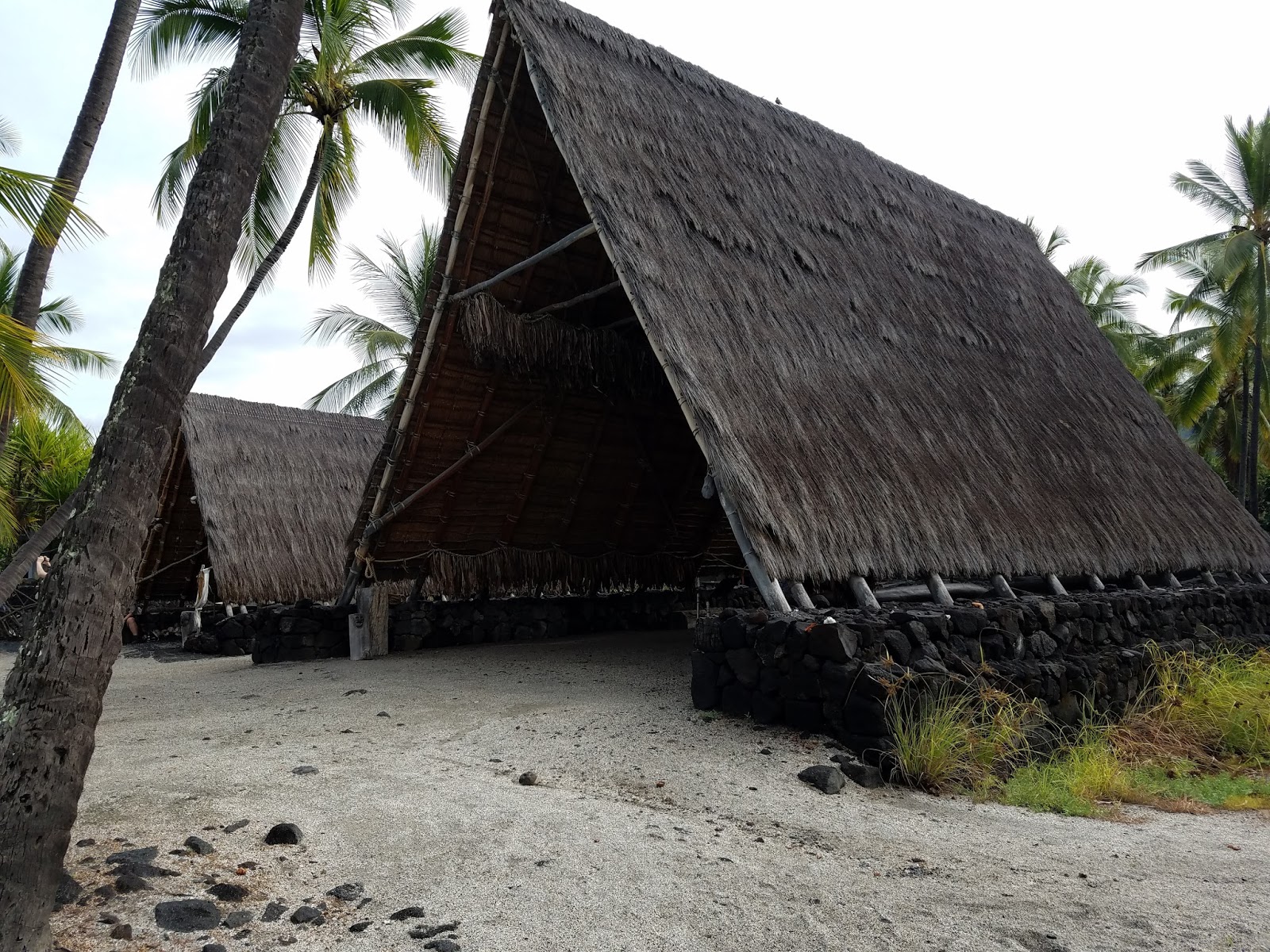
The canoe house within the royal grounds

A fishpond within the royal grounds used to maintain a supply of fresh fish for meals.

A view of the rocky point of the Pu'uhonua.

A view of the enclosure within the Pu'uhonua.  The '13' in the foreground is a marker for the walking tour in the park brochure pointing out the flattened slab to the marker's left, a rock which was used as a game board for the Native Hawaiian game Konane.

The section of the Ala Kahakai National Historic Trail which runs through Pu'uhonua National Historical Park.  The trail runs along Hawaii's west coast, connecting to two other NPS units, Kaloko-Honokohau National Historical Park, and Pu'ukohola Heiau National Historic Site.
A mural of Hawaiian culture at the visitor center.


52. Cowpens National Battlefield, South Carolina


               Hello and welcome back to our blog on the National Park Service.  In this post we visit the location of one of the most pivotal battles of the American War of Independence at Cowpens National Battlefield.

Entrance Sign

BACKGROUND:
               By the winter of 1780-81, the American War of Independence was looking its bleakest since the fall of New York city in 1776.  The British “Southern Strategy,” changing the axis of their offensive to the southern colonies in the hopes of finding greater loyalist support among the populace had thus far succeeded, with the British capturing the cities of Savannah and Charleston and crushing the southern American army at Camden.  While victory at the Battle of Kings Mountain had buoyed American morale, the British still controlled most of South Carolina and all of Georgia.  Hoping to stabilize the situation, George Washington sent two of his best commanders, Generals Nathaniel Greene and Daniel Morgan, to take control of the southern army and challenge the British.
               Upon arriving in the south, Nathaniel Greene went against all military logic and split his army in the hope that the British would do the same.  The British commander, General Lord Cornwallis took the bait, and detached his best troops under the command of dashing cavalry officer Banastre Tarleton to chase after Daniel Morgan’s element of the American army.  Morgan’s force retreated deeper into South Carolina, stopping at a place called “The Cow Pens,” a field where local farmers would graze their cattle.  As Tarleton’s troops approached Morgan arrayed his men in three battle lines.  The first two, made up of local militia would skirmish and wear down the British before falling back, allowing his third line of veteran regulars to finish the fight.
               As Tarleton’s men attacked, Morgan’s strategy unfolded exactly as planned.  The two militia lines fired volleys into the advancing redcoats and pulled back, luring the British straight towards the American regulars.  As the third American line exchanged fire with the British, Morgan’s plan almost unraveled when troops on the American right flank misheard an order and started pulling back leading the British to chase them pell-mell.  At the last moment the Americans wheeled about and fired into the British at point blank range inflicting massive casualties.  The Americans charged while American cavalry under Colonel William Washington, George Washington’s cousin, swooped in around the British flank.  The militia rejoined the fight and soon almost the entire British force was surrounded.  Only Tarleton and the British cavalry were able to escape.
               The Battle of Cowpens was a disaster for the British.  Lord Cornwallis had lost the cream of his army while the American casualties had been light.  The defeat forced Cornwallis into facing Greene two months later at Guilford Courthouse which resulted in an even more disastrous pyrrhic victory.  The double disasters in the south left Cornwallis no choice but to retreat to the Virginia coast where he was cornered by Washington’s army at Yorktown.
               Cowpens would dwindle in the American consciousness thanks to its distance from George Washington who was campaigning in the north, and post Civil War historians who tried to downplay the south's contributions during the War of Independence.  The battle has only recently gotten proper attention following a renewed focus by historians on the southern theater, and thanks to its (extremely historically inaccurate) depiction as the climactic battle in The Patriot

Monument obelisk commemorating the victory at Cowpens located in front of the visitor center.

THE BATTLEFIELD:
               Cowpens National Battlefield is located in northern South Carolina, northeast of Spartanburg.  The area surrounding the battlefield is still rural which has helped preserve the battlefield in its original state.  The actual battle was rather small in scale, with little over a thousand troops for the British and under one thousand for the Americans, and as such the battlefield is rather small compared to other battlefields.  The battlefield is maintained by the NPS to look as much as possible as it did during the battle, a lightly wooded area with somewhat open fields with long grass.  A replica of the original colonial era road runs up the center of the battlefield.  A tour roads circuits the battlefield hidden by woods while trails trace the events of the battle through interpretive signs.  The visitor center is located in the northwest corner of the battlefield near the entrance and provides exhibits and a short film.

A view taken looking along the colonial road from the starting position of the British.  The first of the three successive American battle lines was located in the middle distance of the photo near the cluster of trees with the interpretive sign alongside the road.

TRAVEL TIPS:
               Cowpens National Battlefield is a roughly half-hour drive from Spartanburg, South Carolina and a little over an hour from Charlotte, North Carolina.  The battlefield is open year-round from 9am to 5pm with major holiday exceptions.  For a more authentic experience, visitors are recommended to see the battlefield in the winter as the battle was fought in January.  While the park does have a driving tour, the road is set back from the actual battlefield so some walking will be necessary to properly see the battlefield.  The park trails are paved and handicapped accessible.  Passport stamps can be found at the visitor center.

ADDITIONAL PHOTOS:

The silhouette of the colonial soldier marks the third American line held by Morgan's Continental regulars. 

An early monument on the battlefield erected by the members of the Antebellum era Washington Light Infantry South Carolina militia on the right flank of the third American line where the climax of the battle was decided.


51. Andrew Johnson National Historic Site, Tennessee


               Welcome back to our blog on the National Park Service.  In this post we are traveling to eastern Tennessee to visit the home of the first man elevated to the Presidency in the wake of an assassination, the first President to be impeached, and the man who had the unenviable job of piecing the Union back together in the aftermath of the Civil War.

Entrance Sign

BACKGROUND:
               Andrew Johnson moved into the small town of Greenville, Tennessee as a young man hoping to make a better life.  He set up a tailor shop in town and worked for several years in the trade before entering into politics, getting his first break when he was elected as a town alderman.  Over the years, Johnson’s profile rose steadily, eventually becoming a Senator from Tennessee.
               The outbreak of the Civil War in 1861 put Johnson into a difficult position.  Tennessee had seceded from the Union and joined the Confederacy.  Johnson, despite being both a southerner and a slaveowner, remained loyal to the Union, being the only southern Senator to do so.  In 1864, Abraham Lincoln, wishing to run from reelection on a symbolic unity ticket, chose Johnson as his running mate.  The reelection campaign was successful, and in March of 1865 Johnson ascended to the Vice Presidency.  In this capacity he was not expected to be not much more than a symbolic figurehead given the duties of the Vice President, but Johnson suddenly found himself in the hot seat when Lincoln was assassinated the next month.  Coming at the end of the Civil War, with the south economically destroyed, the north seething with a desire for vengeance, and the uncertainty posed by the abolition of slavery, the elevation of the southerner Johnson to the Presidency could not have come at a worse time.
               From almost the moment he entered the Presidency, Johnson clashed with Congress.  The Republican majority felt the southerner and former Democrat was being far too soft when it came to punishing the south in the aftermath of the war.  The antipathy became so intense that Congress impeached Johnson on frivolous grounds regarding Johnson’s attempt to fire Secretary of War Edwin Stanton.  Johnson narrowly avoided a conviction in the Senate by a single vote but the affair destroyed any remaining political clout Johnson had as President.  Johnson was not successful in gaining the nomination for reelection from either party and retired to his home of Greenville.  Johnson attempted a political comeback several times before finally succeeding by returning to the Senate briefly in 1875 before passing away later that year.

The Johnson Homestead in Greenville, Tennessee.

THE SITE:
               Andrew Johnson National Historic Site is located in the heart of the center of the town of Greenville, Tennessee in the state’s eastern corner.  The site consists of three main areas.  The first is located at the corner of Depot and College Streets.  On the west side of College Street is the site’s visitor center.  Inside the visitor center is Johnson’s tailor shop, protected from the elements by the modern building.  Across the street is the first of two homes owned in Greenville by Andrew Johnson.  This house has only undergone minimal restoration and contains only exhibits.  Three blocks to the south and one street over on Main Street is the second Johnson homestead, purchased after Johnson had risen to wealth and prominence and has been fully restored.  The third area of the site is Andrew Johnson National Cemetery.  Located south of the homestead atop a hill, at the center of the cemetery is an enclosure with the gravesite of Andrew Johnson and his family.

The first home of Andrew Johnson.  The visitor center is across the street to the left.

TRAVEL TIPS:
               Andrew Johnson National Historic Site is located at the center of Greenville, Tennessee, about an hour’s drive from Knoxville and an hour and a half from Great Smoky Mountains National Park.  The site is open year-round, with major holiday exceptions, from 9am to 5pm.  The early Johnson home is open for self-guided tours, while tours of the Johnson Homestead are conducted each hour on the half hour.  There is a fee for tickets to the homestead tours.  The site is handicapped accessible and passport stamps can be found at the visitor center.

ADDITIONAL PHOTOS:

The grave of Andrew Johnson.

A statue to Andrew Johnson across the street from the visitor center and his early home in Greenville.

Andrew Johnson's tailor shop now preserved inside the visitor center.

The bible on which Andrew Johnson took the oath of office and the mourning ribbon he wore following the assassination of President Lincoln, on display in the visitor center.


50. First Ladies National Historic Site, Ohio

               Hello!  Welcome back to our blog on the National Park Service.  For this post, we make another stop at a Presidential home as well as a site dedicated to their wives, the First Ladies, at First Ladies National Historic Site.

Entrance Sign

BACKGROUND:
               In the mid-1990s, a push was made in Congress to establish a repository for documents, research, and commemoration of the First Ladies of the United States.  The location chosen to host this library was the former home of a First Lady, Ida Saxton McKinley in Canton, Ohio.

The home of Ida Saxton McKinley.

               Ida Saxton grew up in Canton, Ohio, the daughter of the local newspaper owner and banker.  In 1871, she married William McKinley, a former Union Army officer who was embarking on a career in politics.  While William rose through the ranks of the Republican party, from member of the House of Representatives and Governor of Ohio, the couple’s personal lives were beset with tragedy.  Both of the McKinleys' two daughters died in childhood, while Ida McKinley suffered from Epilepsy.  While the McKinleys' owned other properties, they continued to spend the majority of their time at Ida’s childhood home, living with her sister’s family.  In 1896, William McKinley was elected the 25th President of the United States, elevating Ida to the role of First Lady, however due to her ill health most of her official duties would be passed the Second Ladies, Jennie Hobart and Edith Roosevelt the wives of McKinley’s Vice Presidents.  Tragedy once again struck the McKinley family when in 1901, the President was assassinated by an anarchist.  Afterwards her health continued to decline until her death in 1907.

THE SITE:
               While it is called First Ladies National Historic Site, most of the focus and interpretation is on the Saxton-McKinley family.  The site is a joint operation between the National Park Service and the National First Ladies Library, and consists of two buildings, the Saxton-McKinley home and a former bank building.  The Saxton-McKinley house passed out of the family’s hands during the 20th Century, and went through extensive reconstructions and remodeling until it was nearly unrecognizable until a team of preservationists acquired the house and began restoration work.  The house as it stands now has been restored to its Victorian Era appearance.
               Further down the street is the building of the former City National Bank.  This building was acquired specifically to house the archives of the National First Ladies Library.  It also functions as the site’s visitor center.

The former City National Bank building which houses the archives of the National First Ladies Library.


TRAVEL TIPS:

               First Ladies National Historic Site is located on Market Avenue in downtown Canton, Ohio.  Tours begin at the visitor center and guests are walked over to the Saxton-McKinley house.  Between the two buildings is a small parking lot and a courtyard.  There is a small admission fee.  The visitor center contains a gift shop and plays a 45-minute film on the history of the First Ladies.  The site is handicapped accessible.  Passport stamps can be found at the front desk in the visitor center, as well as directions from the site to the nearby tomb of President and Mrs. McKinley, also located in Canton.

ADDITIONAL PHOTOS:

The tomb of President William McKinley, also located in Canton.
The dining room of the restored Saxton-McKinley home, with a portrait of Ida McKinley on the wall.

An exhibit in the visitor center showcasing personal artifacts from several First Ladies.

William McKinley's office on the third floor of the Saxton-McKinley house.