Monday, October 7, 2019

49. Shiloh National Military Park, Tennessee


               Hello and welcome back to our blog.  For our latest post we are traveling to southern Tennessee, to the scene of the savage battle that took the Civil War down the path to becoming the bloodiest war the nation has ever fought.

Entrance Sign

BACKGROUND:
               After capturing Forts Henry and Donelson guarding the Tennessee and Cumberland Rivers in February of 1862, the Union army followed up their victory by capturing Nashville and driving up the Tennessee River.  Pushing deeper into Confederate territory, Union General Ulysses S. Grant’s next objective was capture the vital railroad junction of Corinth, Mississippi.  Moving his army upriver, the Union dropped Grant’s army off at Pittsburgh Landing, a water crossing on the Tennessee River near a rural church called Shiloh, just across the Tennessee state line.

The site of Pittsburgh Landing today where Grant's troops disembarked from riverboats prior to the battle.

               The Confederate commander in the western theater, Albert Sidney Johnston, realized the danger of losing the vital railroad junction at Corinth and was determined to prevent the Union from driving deeper south.  Johnston marshalled all available Confederate forces, even stripping precious troops from the garrison of New Orleans, to gather up a large enough force to push back Grant’s army.
               On April 6th, 1862, Johnston’s army attacked the Union encampment at Shiloh.  The dawn attack gave Union troops little time to prepare themselves and the first units engaged were swept from the field.  The Confederates seemed unstoppable at first, swiftly pushing the Union back.  However, the chronically undersupplied Confederates stopped to plunder the Union camps, in particular taking time to eat the breakfasts then in the process of being cooked by Union soldiers.  The delay gave the Union just enough time to reorganize and grind the Confederate offensive to a halt.  Nevertheless, the Confederates continued to hurl themselves at the Union lines, but were unable to break the Union center, where troops were holding in a wooded area along a dirt road.  The position was dubbed “The Hornet’s Nest,” its name taken from the zipping sound of so many bullets being fired from it.  Finally, a combination of massed artillery and flank attacks pushed the Union out of The Hornet’s Nest, but Grant dug in along a last line of defense beside Pittsburgh Landing fortified with heavy artillery and fire support from nearby gunboats.  The Confederates dared not attack the position.

The Hornet's Nest with a monument to Union artillerymen.

              
The next day, with additional reinforcements, Grant counterattacked with such force the Union drove the Confederates off in similar fashion as the Confederates had done the day before.  The Confederates retreated to nearby Corinth and dug in, while the Union lay siege to the town.  However, the Confederates realized further resistance at Corinth would be futile and withdrew.
               The Shiloh campaign turned out to be a disaster for the Confederacy.  In addition to failing to hold Corinth, the Confederate commander Albert Sidney Johnston was killed during the battle, and to make matters worse the depleted garrison of New Orleans could not hold of the Union Navy’s attack only weeks later, leaving the Confederacy's largest port in Union hands.  Most of all though, Shiloh had been a battle unlike any seen in American history.  The casualty count at Shiloh alone was greater than every battle the nation had fought prior to the Civil War combined and began the long string of battles that slaughtered hundreds of thousands through the remainder of the war.

The Confederate Monument at Shiloh.

THE MILITARY PARK:
               The Shiloh battlefield was the among the first four National Military Parks to be established by the U.S. government in the 1890s after Chickamauga & Chattanooga, along with Gettysburg and Vicksburg.  The park has two main areas, the first being the Shiloh battlefield on the banks of the Tennessee River, and the second being a patchwork of properties in and around nearby Corinth, Mississippi.
               The NPS preserved area of Shiloh battlefield covers almost the entirety of the ground fought over in 1862.  As Shiloh remains in a very rural area far from any major town the battlefield is virtually in the same state as it was during the battle, with the obvious exception of monuments and park amenities, and there is no development encroaching on the park.  Surrounded by the battlefield, but not on actual park lands because it is still an active congregation, is the Shiloh church from which the battle takes its name.  A replica of the original log cabin church sits next to a more modern church built in the early 20th century.  Located next to the visitor center is Shiloh National Cemetery where the Union interred their dead following the battle.  As the Union held the field following the engagement the Confederate dead were buried in several mass graves.  In addition, the park preserves the Shiloh Indian Mounds National Historic Landmark, a series of earthen mounds from an ancient Indian settlement on the banks of the Tennessee River which happened to be on the edge of the battlefield.

The replica (at left) and modern Shiloh church.

               The Corinth Unit of Shiloh National Military Park is spread out in small parts around the nearby town of Corinth, Mississippi, preserving areas involved in first the siege of Corinth which took place immediately following Shiloh, and the Battle of Corinth where Confederates attempted to retake the town in October of 1862.  The Corinth Unit is much less developed than the Shiloh battlefield but does have a separate visitor facility, the Corinth Civil War Interpretive Center.

A restored earthwork artillery battery adjacent to the Civil War Interpretive Center in Corinth.

TRAVEL TIPS:
               Shiloh National Military Park is located in southwest Tennessee, a roughly two-and-a-half-hour drive from Nashville, and a little over and hour’s drive from Tupelo, Mississippi.  It is a little under a half hour’s drive from the Shiloh battlefield to the Civil War Interpretive Center in Corinth, Mississippi.  The park grounds are open from dawn until dusk and both visitor centers are open from 8am to 5pm year-round with holiday exceptions.  Both visitor centers showcase short films and exhibits as well as artifacts from the battles of Shiloh and Corinth.  The park brochure provides a map for a driving tour of the Shiloh battlefield and the route from Shiloh to Corinth.  Visiting both the Shiloh battlefield as well as the Corinth sites can be done within one day.  The park is handicapped accessible and passport stamps can be found at both visitor centers.  Reenactment events are held yearly near the anniversary of the battle.


ADDITIONAL PHOTOS:

The cannon alongside the road mark the line where Grant's troops finally stopped the Confederate advance on the first day of the battle and from where the Union launched its counterattack the next day.

The monument to Union troops from Iowa just behind the final Union defensive line.

The position of where the Confederates massed their artillery to bombard the Union position in The Hornet's Nest , which was concealed in the treeline in the distance.  The tents being erected in the background are part of preparations for the annual battle reenactment.

A Memorial fountain located in the rear of the Civil War Interpretive Center in Corinth.


Friday, June 28, 2019

48. Gauley River National Recreation Area, West Virginia


               Hello again and welcome back to our blog.  In this post we are returning to the second of three rivers in southwestern West Virginia.

Entrance Sign

BACKGROUND:
               Upon being dammed in the early 1960s to form Lake Summerville, it was discovered that the Gauley River, a tributary which forms the Kanawha River when it flows into the New River, was a prime location for whitewater rafting.  The river soon became a hot spot for professional kayakers and whitewater rafters, and every autumn during "Gauley Season" water is released from the dam to help create the Gauley’s notoriously difficult rapids.

The Summerville Dam.

THE RECREATION AREA:
               The Gauley River National Recreation Area consists of a section of the Gauley River gorge, running from the Summerville Dam, to the small locality of Swiss in southwestern West Virginia, nearby New River Gorge National River.  While there are hiking and fishing opportunities, the Gauley is best known for its perilous rapids, particularly during times of high water, such as in autumn when controlled releases from the Summerville Dam increase the water level.  The river has many Class V rapids, beginning with the sarcastically named “Insignificant Rapids,” the names of the rapids become more ominous the further downstream one heads with examples such as “Lost Paddle,” “Heaven Help You,” and “Pure Screaming Hell” rapids.
               The river has no visitor centers or park facilities.  All NPS visitor services are provided by the nearby New River Gorge National River.

A calm stretch of the Gauley River.

TRAVEL TIPS:
               Gauley River National Recreation Area is roughly a half hour drive from Beckley, West Virginia.  The Recreation Area is open year-round.  The nearest NPS visitor center is the Canyon Rim Visitor Center at New River Gorge National River.  There are several private contractors that are permitted by the NPS to operate rafting tours in the New River Gorge vicinity.  Given the dangerous nature of the Gauley River’s rapids, it is recommended that unless visitors are highly experienced in whitewater rafting or kayaking, that these authorized companies be used for visitors’ rafting rides on the Gauley.  It is also recommended that unless visitors are again highly experienced in whitewater rafting, visitors should visit in mid-summer when the water level is much lower and the rapids are less treacherous.  The Recreation Area is not handicapped accessible.  Passport stamps can be found at the New River Gorge National River visitor centers.

A bend in the Gauley River as seen from an overlook at Carnifex Ferry Battlefield State Park, site of a Civil War skirmish in 1861.  "Pillow Rock Rapids" can be seen at lower right.


Wednesday, May 8, 2019

47. Steamtown National Historic Site, Pennsylvania


               Welcome back to our blog!  In this post we are traveling to eastern Pennsylvania to one of the few remaining sites in the country which preserves the legacy of steam powered locomotives.

Entrance Sign

BACKGROUND:
               With the harnessing of steam power during the early 1800s, the economy of the United States boomed as the power source drove the industrial revolution.  Key to the expansion of the nation was the steam locomotive, which was equally revolutionary as a transportation method.  By the end of the Civil War, tens of thousands of miles of railroad tracks had been laid, connecting the nation as never before.  Following the completion of the Transcontinental Railroad, the industry exploded as rail service became the biggest business of the century.  The period from the late Gilded Age of the 1890s, through to the beginning of World War Two, was a golden age of steam locomotives.

A vintage steam engine originally built in 1903, on display at Steamtown NHS.

               In the aftermath of the war however, technology changed.  Train engines switched to diesel power, which negated the need for much of the infrastructure that kept the steam railroads in service for so many decades.  Rail lines fell out of use as passenger travel dried up with the advent of the Interstate Highway system and mass air travel, and maintenance yards went quiet, soon to be demolished due to lack of use.
               However, one vintage railyard hung on through the efforts of preservationists.  Amassing a collection of steam locomotive engines dating from the first four decades of the 20th century, the Steamtown Foundation worked to open a museum centered on a surviving steam railyard with a working turntable in Scranton, Pennsylvania.  The foundation’s efforts won favor with local politicians who backed a bill in Congress to designate the museum a National Historic Site in 1995.

A view of the exterior of the roundhouse and the turntable at Steamtown.

THE SITE:
               Steamtown National Historic Site is located at the center of Scranton, Pennsylvania at the former railyard of the Delaware, Lackawanna and Western Railroad, or DL&W.  The site preserves a little over sixty acres of the railyard, along with many historic structures.  The center of the site is the roundhouse, once a massive circular garage that served as a maintenance shed for over forty engines, complete with a functioning turntable.  The roundhouse is split into two halves, the eastern half is primarily an original structure and is still used for the maintenance of the working steam engines at the site.  The western half of the building has been mostly reconstructed and serves as the visitor center and museum.  Adjacent to the roundhouse, the former oil pump building now serves as the site bookstore.  On the north side of the railyard along several connecting rail sidings, the site hosts a large collection of vintage steam engines, passenger and freight cars, and other rail vehicles.  Although it shares a parking lot with Steamtown but is not a part of the site, is the Electric city Trolley Museum, which focuses on the history of streetcars.

A model on the second floor of the visitor center showing the roundhouse and the railyard as they appeared in their heyday in the late 1930s.

TRAVEL TIPS:
               Steamtown National Historic Site is open from 9am to 5pm from April through November, and 10am to 4pm during the winter months.  The site offers a variety of train rides using the operating locomotives at the side, ranging from short trips around the vicinity of the railyard to extended excursions around the Scranton area.  These rides are not regularly scheduled events and visitors are recommended to check the special event schedule on the site’s webpage prior to visiting.  The site has no entrance fee, although the train rides are an additional fee.  The visitor center features a short film and passport stamps can be found in the bookstore.  The site is only partially handicapped accessible.  Visitors are strongly advised to be aware of their surroundings at the railyard.  The operation of the large steam engines at the site is inherently dangerous, and there has unfortunately been at least one fatal accident involving one of the site’s engines. 

While it may be difficult to see from the photo, here an engine hauls a caboose filled with riders on an excursion through the railyard.

ADDITIONAL PHOTOS:

An additional view of several engines parked inside the yard of the roundhouse.

The business end of the 790 Engine.

A view of the roundhouse office.

A cutaway showing the interior workings of a steam engine in the visitor center.

A view of the interior of the still functioning maintenance side of the roundhouse.

A view from the second floor of the roundhouse showing the collection of freight and passenger cars in the railyard.

The Baldwin Locomotive Works Engine 26 backs onto the turntable to be returned to the roundhouse for the night.

The Electric City Trolley Museum, located at the opposite end of the parking lot from the roundhouse.


Monday, April 8, 2019

46. Dry Tortugas National Park, Florida


               Hello and welcome back to our blog!  In this post we are visiting arguably the most remote National Park in the contiguous U.S., Dry Tortugas National Park.

Entrance Sign.  (Photo courtesy of Mark and Maureen Costa)

BACKGROUND:
               Located seventy miles west of Key West, the Dry Tortugas are the last in a long chain of islands known as the Florida Keys.  First charted by Conquistador Ponce de Leon, the islands were dubbed Las Tortugas, “The Turtles” in English.  The name was later changed to Dry Tortugas due to the small islands lack of freshwater.
               After Florida was acquired from Spain by the United States, the U.S. Army began working on fortifying Florida in keeping with U.S. doctrines on seacoast defense.  The U.S. Navy believed that the natural anchorage at the Dry Tortugas could be used as a base of operations by a hostile navy in the event of war, threatening American trade routes through the Gulf of Mexico.  In order to prevent this, the Army commissioned the construction of Fort Jefferson to guard the anchorage.

The moat and front wall of Fort Jefferson.

               Construction on the fort would continue for two decades.  Owing to its remote location, the pace of building dragged on with little urgency.  With the outbreak of the Civil War, the Union retained possession of Fort Jefferson and converted it into a prison camp.  Its most infamous prisoner was Dr. Samuel Mudd, who had been caught up in the Lincoln Assassination Conspiracy (he had provided medical care to John Wilkes Booth following the assassination).  After assisting medical personnel at the fort following an outbreak of malaria, he was granted clemency and released. 
               Advances in naval artillery rendered the fort, constructed of comparatively fragile masonry, obsolete and with the anchorage it was meant to protect now seen as having little strategic value, Fort Jefferson was given to the navy for use as a coaling station for steam vessels.  Eventually the military gave up possession of the fort and it was established as a National Monument in 1935, later becoming a National Park in 1992.

The front wall and main entrance of Fort Jefferson as seen from the third level of the fort.

THE PARK:
               Dry Tortugas National Park is located approximately 70 miles west of Key West, Florida.  The Park is roughly 73 square miles in area, 99 % of which is open ocean.  There are seven islands in the park.  East, Middle, and Hospital Keys are small islets not much larger than sandbars and are off limits to the public as they are nesting grounds for endangered sea turtles.  The westernmost island is a long narrow strip of land called Loggerhead Key, which is topped with a lighthouse and is only accessible, via private watercraft.  In the center of the park is Garden Key, the home of Fort Jefferson.  Neighboring to the east are Bush Key, and Long Key, which may be connected together with Garden Key by a sandbar depending on sea currents and erosion.
               Fort Jefferson on Garden Key is a six sided, three-tiered, masonry fort.  Constructed with over sixteen million bricks it is the largest masonry structure in North America.

A view from atop the fort looking at Bush Key and Long Key, connected to Garden Key as of December 2018 by temporary land bridge.  The sandbar connecting the island comes and goes over the decades depending on water currents and erosion.  As recently as 2004 the islands were completely separated.

TRAVEL TIPS:
               Due to its remote location, Dry Tortugas National Park can be visited only by a select few methods of travel.  While private watercraft can travel to park, the most common option for visitors is to take the Yankee Freedom III ferry from Key West.  The ferry operates once daily, departing Key West at approximately 9am and returning approximately at 5pm.  While it is possible to purchase tickets the day before at the ferry dock ticket office, available space aboard the ferry is limited and advance tickets are almost always required.  The ferry ride is roughly two and a half hours from Key West to Garden Key.  The crew of the Yankee Freedom III provides meals for both breakfast and lunch as well as sales and rental of snorkel equipment.  In addition to the Yankee Freedom III, several companies operate float planes which deliver guests to the islands.

The Yankee Freedom III ferry docked at Fort Jefferson.

               Camping is permitted overnight on Garden Key.  Reservations must be made through the Yankee Freedom III, however facilities on the island (restrooms and showers) are nonexistent.  The only flush toilets are located aboard the Yankee Freedom III while there are vault toilets on the island.
               Fort Jefferson is an inherently dangerous environment, so caution is to be exercised while exploring.  The fort itself has no railings along the upper levels to prevent someone from falling, falling bricks from loose masonry though very rare may be possible, and there are no lifeguards for those who wish to go snorkeling.  There are two snorkel beaches on the north and south sides of the island near the ruins of the former coaling docks.
               A section of the fort is off limits to the public as it has been converted into modern housing for the park staff assigned to the island who live there a full year.  The fort is not handicapped accessible beyond the lower floor. Passport stamps can be found at the gift shop in the visitor center, located on the lowest level of the fort immediately north of the main entrance. 

ADDITIONAL PHOTOS


Pelicans perch atop posts at the private boat dock.

A view of Long Key taken from Bush Key.  Long Key is a wildlife refuge and is off limits to the public.

A Portuguese Man-Of-War washed ashore on Bush Key.  This is one of several that the authors encountered along the beach.  This species of jellyfish is very dangerous and potentially deadly even to humans.  Barely visible next to the jellyfish is a hole from which a crab had exited mere moments before this photo was taken.  The crab retreated immediately on finding the jellyfish.

The gallery of the first level of the fort.  Originally this would have been lined with cannon.

The parade ground of the fort as seen from above.

A chartered float plane comes in for landing.  Note the tents in the small camping area in the foreground.

The fort's lighthouse, undergoing restoration at the time of the authors' visit.

Cacti growing atop the wall on the third level of the fort.  The Dry Tortugas are extremely arid and temperatures can be punishing even in the winter.  One park staff member joked to the authors, "If you think this is bad you should see it July!"

A view of the north snorkel beach next to the ruins of a coaling dock.

A large section of the moat's retaining wall which had been damaged by recent hurricanes.


Saturday, February 16, 2019

45. Kings Mountain National Military Park, South Carolina


               Hello!  Welcome back to our blog on the National Park Service.  In this post we travel south to the location of a major turning point in the American War of Independence, the battle of Kings Mountain.

Entrance Sign

BACKGROUND:
               While the situation of the American War of Independence had reached a stalemate in the northern colonies, the British had seen major successes in the south in 1779 and 1780.  Beginning with the capture of Savannah, the British had marched from to victory to victory, essentially evicting American forces out of Georgia, capturing Charleston, South Carolina, and shattering the only major American army in the south at the Battle of Camden.
               With American forces routed, the British hoped to capitalize on the greater amount of Loyalist support among the southern populace.  The British strategy called for Loyalist militias to shoulder the bulk of maintaining order in the south while the British regulars would march north, rolling up the colonies from the south and eventually pinning and destroying George Washington’s army in the north.  To do this, the British sent out veteran Major Patrick Ferguson, a noted marksman who had patented a new rifle design, to raise Loyalist troops and crack down on American supporters.  Ferguson’s heavy-handed tactics alienated the populace and galvanized American militiamen in the mountains of western North Carolina and eastern Tennessee.

The densely wooded forest in which the battle was fought.  The hilltop of Kings Mountain is at the center of the photo.

               In October of 1780, swarms of militiamen converged on Ferguson’s position at Kings Mountain, near the border between the two Carolinas.  Ferguson initially believed his position atop the prominent hilltop to be advantageous, but it soon turned into a death trap as the American militia completely encircled the Loyalists.  The militiamen charged up the hill, using frontier tactics to whittle away the Loyalist defenders.  At the height of the fighting, Ferguson fell from his horse, riddled with bullets from a volley of fire.  Loyalists began to attempt to surrender, but chaos reigned in the heat of battle and militiamen continued to gun down Loyalists until American commanders were finally able to regain control of the situation.
               With the destruction of Ferguson’s Loyalist force, the British strategy took a major blow as local support dried up and American forces engaged in a guerilla campaign.  The delay to British plans allowed the American army to regroup, leading to the decisive victory at Cowpens in January of 1781.

A monument atop Kings Mountain dedicated on the centennial of the victory in 1880.

THE MILITARY PARK:
               Kings Mountain National Military Park was established in 1931 following massive celebrations commemorating the 150th Anniversary of the battle the year prior.  The park preserves a huge tract of land surrounding the eponymous hill on which the battle was fought.  The park was originally much larger, but the entire eastern half was given over the state of South Carolina and converted into a state park.  The park is located in a very rural area and the combination of this and the sheer size of the park has allowed the battlefield to remain in near the same condition as it was during the battle.  In addition to the visitor center and the Battlefield Trail, the park includes horseback riding trails which overlap with the adjacent state park, and a backcountry campground.  The park is also the terminus of the Overmountain Victory National Historic Trail, which traces the routes used by militiamen to reach the battlefield at Kings Mountain.

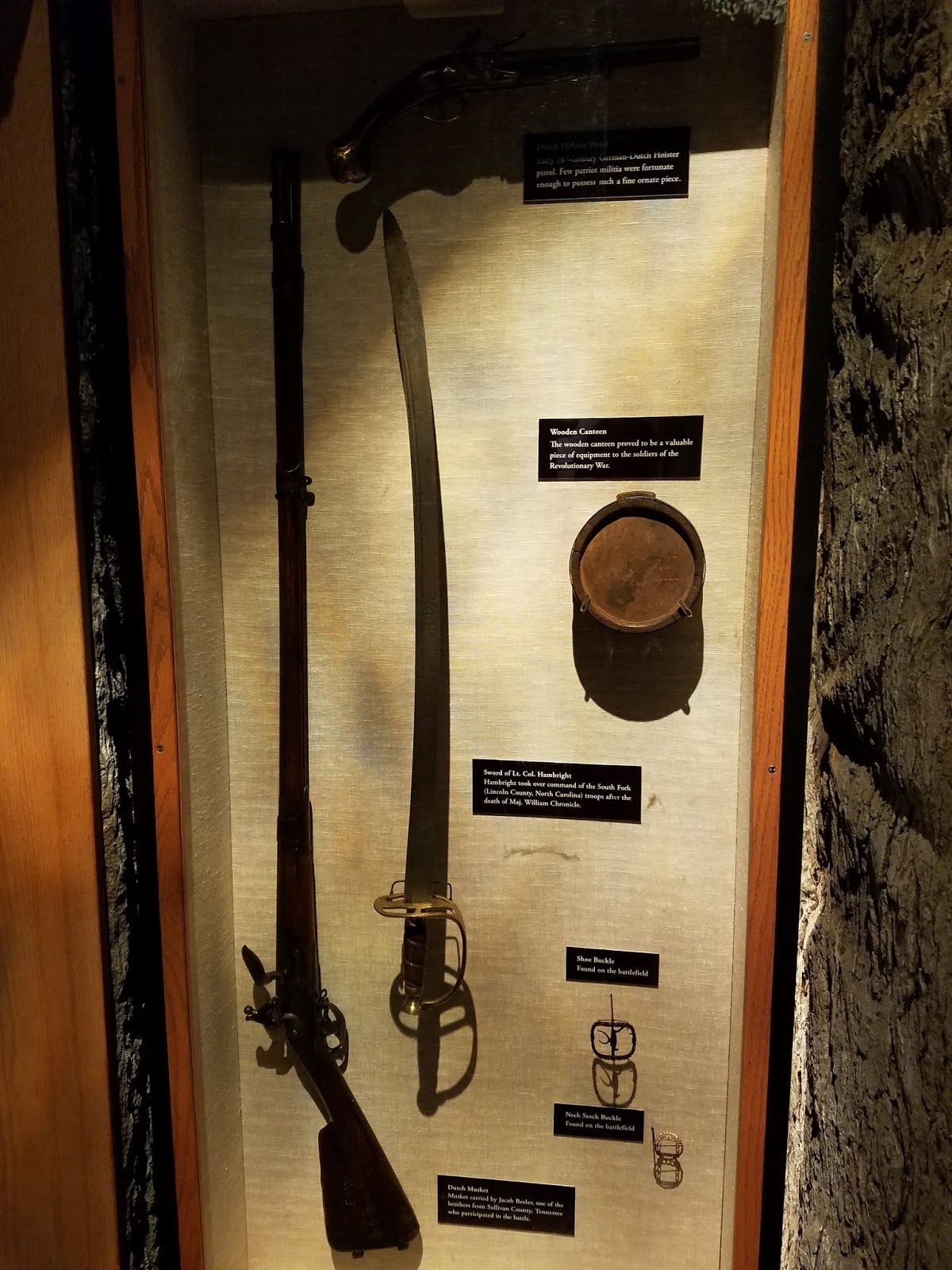
Artifacts belonging to American militiamen who fought in the battle on display in the visitor center.

TRAVEL TIPS:
               Kings Mountain National Military Park is located in northern South Carolina, roughly a forty-five-minute drive west of Charlotte, North Carolina.  It is possible to visit and walk the battlefield in less than two hours.  The visitor center contains a short film and exhibits on the battle including artifacts used by participants.  The Battlefield Trail is paved and handicapped accessible.  Passport stamps can be found in the visitor center.

ADDITIONAL PHOTOS:

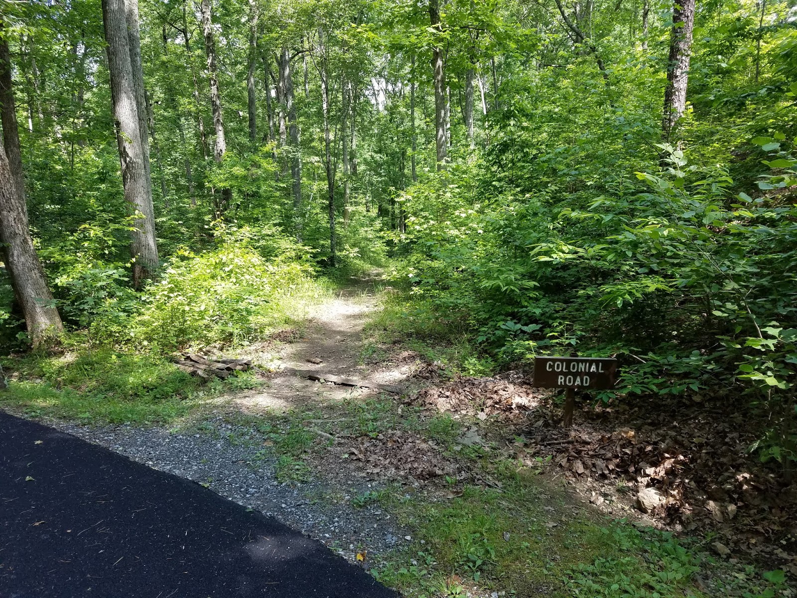
The trace of the colonial road which once ran past the hill.

A marker commemorating the 150th Anniversary celebrations in 1930 which were presided over by President Herbert Hoover.

A stone on the hilltop marking the spot where the British commander Major Ferguson was killed during the battle.

A topographical light board in the visitor center which reconstructs for visitors the events of the battle. 

The grave of Major Ferguson, located at the base of Kings Mountain.