Monday, September 24, 2018

40. George Rogers Clark National Historical Park, Indiana


               Hello and welcome back to our blog.  In this post we travel to Indiana to visit the memorial to the man whose exploits secured the northwest for the United States and opened the west to expansion.

Entrance sign.

BACKGROUND:
               In 1778, as the American War of Independence dragged on, the governor of Virginia, Patrick Henry, approved an expedition to secure American claims to the territory between the Appalachian Mountains and the Mississippi river.  To command this expedition, Virginian George Rogers Clark was appointed to lead men down the Ohio river and capture several British forts in the Illinois wilderness.  Despite having a far smaller army than promised, Clark seized the British posts with complete surprise and managed to broker peace with several Indian tribes.  During the winter the British struck back, the British governor of the Northwest Territories, Henry Hamilton, personally leading a force from Detroit which recaptured Fort Sackville on the eastern bank of the Wabash river.
               Clark, realizing that a British resurgence might erase all of the Americans' gains, gathered up his small force and marched back across Illinois from St. Louis in the dead of winter.  As they approached their objective, Clark and his men came across the Wabash river, swollen from winter snows and rains which had turned the entire area around Fort Sackville into an icy swamp.  Undaunted, Clark lead his men onward, wading through miles of freezing cold water.  Finally, after completing the arduous march, Clark’s troops assaulted Fort Sackville.  Thinking that he was facing a far superior force, the Governor Hamilton surrendered to Clark on February 25th, 1779.  The capture of the British posts throughout the frontier allowed the United States to go into peace negotiations with a much stronger bargaining position, allowing the new nation to firmly claim the Northwest Territory, the modern states of Ohio, Indiana, Michigan, Illinois, and Wisconsin.
               As for George Rogers Clark himself, despite his heroics in helping win the west, he was soon eclipsed in fame by his younger brother William Clark, who along with Meriwether Lewis led the Corps of Discovery on their famous journey across the west to the Pacific Ocean.  To memorialize this overlooked hero, the state of Indiana with assistance from the Federal government, commissioned a memorial to Clark on the location of Fort Sackville in Vincennes, Indiana.  The classical style monument was completed in 1936 and designated a unit of the National Park Service in 1966.

The statue at the center of the monument rotunda memorializing George Rogers Clark.

THE HISTORICAL PARK:
               George Rogers Clark National Historical Park is located on the east bank of the Wabash river in the center of Vincennes, Indiana.  The park consists of a large park space surrounding the George Rogers Clark monument along with a visitor center.  The monument is a classical style granite rotunda, at the center of which is a larger-than-life bronze statue of George Rogers Clark.  Along the walls of the rotunda are murals depicting Clark’s campaign to capture Fort Sackville.  On the park grounds are two additional statues, one memorializing Francis Vigo, an Italian merchant who acted as an American spy and helped bankroll Clark’s expedition.  The second lies in front of the Old Cathedral of Vincennes depicting Father Pierre Gibault, a French Priest who aided Clark by rallying the French inhabitants of the region to the American cause.
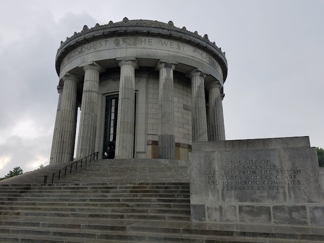
The exterior of the monument.

TRAVEL TIPS:
               George Rogers Clark National Historical Park is open year-round with holiday exceptions from 9am to 5pm daily.  The park is located at the center of downtown Vincennes, Indiana, a roughly two-hour drive southwest from Indianapolis.  The visitor center contains a short film.  The monument, having been built in the 1930s, is not handicapped accessible.  Passport stamps can be found at the visitor center.  In addition, Vincennes is home to several other historic sites, including Grouseland, the mansion of President William Henry Harrison, which may also be of interest to visitors.

ADDITIONAL PHOTOS:

A distant view of the monument.

Two of the murals in the rotunda, depicting the opening of Ohio to settlement at Marietta, and the Louisiana purchase at St. Louis, both made possible by George Rogers Clark's seizure of Fort Sackville.

A statue of Francis Vigo, Clark's financier, on the bank of the Wabash river.


Saturday, September 15, 2018

39. Chickamauga and Chattanooga National Military Park, Georgia


               Hello and welcome back to our blog!  In this post we are visiting the first ever park dedicated to preserving a battlefield at Chickamauga and Chattanooga National Military Park.

Entrance Sign

BACKGROUND:
               By September of 1863, the Confederacy had suffered devastating defeats at Vicksburg and Gettysburg and had been pushed completely out of Tennessee.  The Union was now preparing for a new offensive into Georgia to take the south’s vital industrial hub of Atlanta.  Hoping to stem the tide, the Confederates shipped in as many reinforcements to the Army of Tennessee as possible.  Just south of Chattanooga, along the banks of a creek called Chickamauga, alleged to mean “River of Death,” the Army of Tennessee attacked their Union counterparts the Army of the Cumberland.

The Georgia state monument at the Chickamauga battlefield.

               The first day of fighting ended in a tactical stalemate.  On the second day fighting resumed, the armies aligned parallel to each other running north to south slugging it out at close range.  As the day dragged on, an erroneous report reached Union command that a hole had opened in the center of the Union line.  Union General William Rosecrans, commander of the Army of the Cumberland ordered the gap closed.  However, Rosecrans’ chief of staff, future President James A. Garfield, was occupied dictating a previous order, and so the order was given to another subordinate who misunderstood it.  The order was passed down to Union commanders who then moved their unit out of the line, opening up a real gap where the fictitious one had been.  Confederate troops saw their chance and poured into the breach.

Markers along the tour route marking the location of Confederate units during the battle.  The two sides were locked in such close combat...

...that their Union counterparts were located just on the opposite side of the road less than one hundred yards apart.

               With the exception of a lone Union cavalry brigade at the extreme southern end of the line who managed to hold due to the firepower from their quick-shooting repeating rifles, the entire Union right flank collapsed.  Thousands of Union troops began fleeing to the northwest back to Chattanooga, Rosecrans among them.  However, the left flank under General George Thomas continued to hold.  Despite continuing ferocious Confederate assaults, Thomas’s troops held their ground until nightfall when they retreated under the cover of darkness back to Chattanooga.  For his stout defense of the Union flank, Thomas was heralded as “The Rock of Chickamauga.”

The Monument to Wilder's Brigade, the Union force cut-off at the extreme southern end of the Union line following the rout of the Union right flank.  The castle tower-like monument can be climbed by visitors.

               The Confederates now occupied the high ground surrounding Chattanooga, namely Missionary Ridge to the southeast and Lookout Mountain to the southwest.  In order to relieve the bottled-up Union army, Ulysses S. Grant, fresh off his crushing victory at Vicksburg, raced east.  Wasting no time, Grant led his troops in a series of daring attacks in October, starting with the stunning capture of the mighty Lookout Mountain in an action called “The Battle Above the Clouds.”  Then turning his entire force to face Missionary Ridge, the Union army charged up the entire length of the ridge-line, sweeping the Confederates off the heights.  Grant’s counterattacks were so devastating it turned a potentially crucial Confederate victory after Chickamauga into a crippling defeat following Chattanooga.

Chattanooga as seen from atop Lookout Mountain.


THE MILITARY PARK:
               Chickamauga and Chattanooga National Military Park was the very first battlefield to be preserved for its historical significance by the Federal Government in 1890, beating out even the famed Gettysburg.  It was initially managed by the War Department (the Army precursor to the Defense Department) before being transferred to the National Park Service in 1933.  The Military Park as it exists today consists of two major areas in the vicinity of Chattanooga, Tennessee, and several smaller plots of land in the area.
               To the south of Chattanooga, just inside the Georgia state line is the Chickamauga battlefield.  The battlefield comprises a large square shaped area of land and owing to its early park establishment is preserved in much the same state as it was during the battle.  However, in the century since the park was established the suburbs of Chattanooga have expanded greatly and now virtually surround the battlefield.  The Chickamauga battlefield visitor center is located near the north entrance to the battlefield and a road circuits the battlefield for a driving tour.

The historic visitor center at the Chickamauga battlefield.

               Farther north is the other main portion of the battlefield, Lookout Mountain.  While the top plateau of the mountain was turned into an upscale suburb, the flanks of the mountain where much of the fighting took place is protected by the Military Park.  In addition, at the very tip of the mountain is Point Park, now administered by the NPS, which overlooks the city of Chattanooga from former Confederate artillery positions and which later became a popular location for Union troops to pose for photographs.  A second visitor center is located at the entrance to Point Park.  Most of the rest of the Chattanooga battlefield has been swallowed up by the growth of the city.  Several small areas are protected by the NPS, namely a small acreage at a battlefield locale called Orchard Knob and several plots of land along the length of Missionary Ridge.  There is also a section of the park located on the Moccasin Bend peninsula across the Tennessee River from the city reserved for archaeological digs and is not open to the public.

The entrance to Point Park atop Lookout Mountain.

TRAVEL TIPS:
               Chickamauga and Chattanooga National Military Park is open year-round, with grounds open from sunrise to sunset and visitor centers open from 8:30am to 5:00pm.  There is no fee to enter the Chickamauga battlefield but a fee is required at Point Park on Lookout Mountain.  While the Military Park is spread out across the vicinity of Chattanooga it is possible to visit the entirety of the park in the span of a day.  The park brochure provides a driving tour of the battlefield and both visitor centers contain a short film.  The Chickamauga battlefield is handicapped accessible while the Lookout Mountain battlefield is partially accessible.  Passport stamps can be found at both visitor centers.


ADDITIONAL PHOTOS:

A view across the open fields at the north side of the battlefield from the position of Confederate batteries.  General George Thomas's troops were located in the area of the treeline.

A Monument to Ohio artillerymen at the Chickamauga battlefield.

The New York monument at Point Park at the summit of Lookout Mountain.


A second view from Point Park on Lookout Mountain.  The Moccasin Bend Peninsula is located at the left of the photo.  Missionary Ridge is marked by a line of foliage running across the frame from the center of the picture straight across to the right about a quarter of an inch below the horizon.