Monday, June 12, 2017

8. Friendship Hill National Historic Site, Pennsylvania


               Hello!  Welcome back to our blog on National Park Service Units.  In this post, we’ll be examining Friendship Hill National Historic Site located in southwest Pennsylvania not far from our last unit Fort Necessity National Battlefield.  Friendship Hill was the country estate of Albert Gallatin, an early American statesman best remembered for his tenure as Secretary of the Treasury.

 
Entrance Sign

BACKGROUND:

               In 1780, a young man from Switzerland named Albert Gallatin emigrated to the United States hoping to find success in the newly independent nation.  He settled in western Pennsylvania, then still rugged and barely tamed frontier, working as a surveyor, before gaining an interest in land speculation.  After amassing wealth, Gallatin bought a large farm in 1789 overlooking the Monongahela river in southwest Pennsylvania for himself and his new bride Sophia, who died only months later.  He soon became a well-known member of the local community and entered into politics, first becoming a delegate to the Pennsylvania state constitutional convention, then as a member of the state Assembly.  His political stock continued to rise as he was elected to the House of Representatives, and chosen in 1801 by President Thomas Jefferson to be Secretary of the Treasury.  Gallatin would serve in this capacity for the next fourteen years, being retained as head of the Treasury Department by Jefferson’s successor James Madison.  During his tenure, Gallatin would be instrumental in securing financing for some of the nation’s most momentous projects, including the Louisiana Purchase and the National Road.  In 1814, he would serve on the delegation that negotiated the Treaty of Ghent which brought an end to the War of 1812.  He would later serve as minister (ambassador) to both France and Britain, helped established New York University, founded the American Ethnological Society, and was President of the National Bank of New York.

Statue of Albert Gallatin in front of the Department of the Treasury building in the District of Columbia

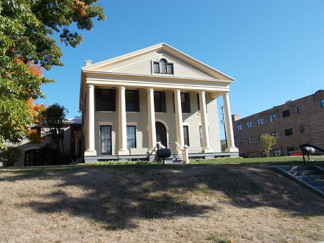
While his career path trended ever higher, Gallatin continued as best he could to maintain his Pennsylvania farm which he had purchased in 1789.  Naming it Friendship Hill, Gallatin would continue to expand the property from the original brick house he had built for himself and his first wife into a gradually larger country estate.  However, Gallatin’s second wife, Hannah, a New York city native, did not share his passion for rural life.  Caught between his wife’s personal wishes and his governmental duties, Gallatin would see less and less of his Pennsylvania estate, finally selling off the property in 1832.  The house passed through a series of private owners, and was nearly destroyed by arson before being acquired by the National Park Service in 1978.

 
Albert Gallatin's Friendship Hill

THE SITE:

               Friendship Hill is located in Fayette County, Pennsylvania, in the state’s southwest corner only a few miles from the West Virginia border and a little over an hour south of Pittsburgh.  The current site is almost double the size of Gallatin’s original land holdings as subsequent owners added land to the property.  Most of the property functions as a normal park with many miles of trails.  The main attraction though is the Gallatin House.

The estate grounds as seen from the mansion

              A roadway leads from the park entrance across a large meadow to a parking lot at the base of the hill atop which the house is perched.  A small picnic area and restrooms are located next to the parking lot.  A paved path winds up the hill from the parking lot to the house, where the visitor center is located within the mansion.  The visitor center is located on the ground floor in a later addition to the house.  It contains several artifacts from the Gallatin family on display and has two short films.  The house itself has been mostly restored to its original appearance, however some areas are explicitly left unrestored so that visitors may see the how the house was first built.  The majority of the house however is sparsely furnished, with only a handful of rooms containing furniture.

               A short walk downhill from the mansion into a wooded area overlooking the Monongahela river, visitors will also find a stone rectangle, the site of the grave of Gallatin’s first wife Sophia.

 
The grave of Sophia Gallatin

TRAVEL TIPS:

               Friendship Hill National Historic Site is open year-round, however winter hours can fluctuate so it is recommended to visit in the summer.  The Gallatin mansion can be viewed on a self-guided tour, and the grounds also have a cell phone tour.  Passport stamps can be found in the visitor center area of the mansion.  The site is handicapped accessible and there is no entrance fee.  It is also in close proximity to Fort Necessity National Battlefield and both sites can be easily viewed within a single day.
We hope you enjoyed this summary of Friendship Hill National Historic Site.  Our next post will be part of our celebration of Independence Day as we will be visiting Massachusetts and the events that began the American War of Independence at Minute Man National Historic Park.

ADDITIONAL PHOTOS:
A statue of Gallatin as a surveyor on the path from the parking lot to the mansion

The view of the Monongahela river from the estate's overlook

The mansion's parlor, where Gallatin entertained the Marquis de Lafayette (seen in the portrait) during a visit in 1825


Artifacts in the visitor center including Gallatin's signet ring (at lower left)

A second view of the Gallatin mansion
The stone kitchen at Friendship Hill.  Fire damage to the original structure can be seen in some places on the chimney

7. Fort Necessity National Battlefield, Pennsylvania


Welcome back to our blog!  Our latest entry takes us to southwest Pennsylvania, and a place where a chain of events began that set the Thirteen Colonies on the road to independence, and where George Washington made his first impact on the course of history.

 
Entrance Sign

BACKGROUND:

               In the year 1754, North America was mostly divided between the colonial domains of Britain and France, Britain holding the coastal 13 colonies, France holding Canada and the interior over the Appalachian mountains.  Both countries hope to seize the confluence of the Allegheny and Monongahela rivers, thereby controlling the Ohio river.  Both sides sent military expeditions, but while the British arrived first, a larger French detachment forced them out and began building a redoubt at the confluence named Fort Duquesne.  British forces, under the command of a young officer in the Virginia militia named George Washington, camped a few days march away at a clearing called Great Meadows.  When Washington received a report that a small unit of French troops were making their way towards his encampment, not knowing their intentions, Washington chose to ambush them.  His decision would begin a world war.

               Washington’s forces engaged the French unit under the command of an officer named Jumonville in a small skirmish, killing or capturing all but one of the French.  Upon hearing of the attack, the French sent a large force to annihilate the British.  Washington fell back to his camp and hastily erected a fort, dubbed Fort Necessity.  The French and a vast number of Native American allies struck before the British were prepared, and on July 3rd attacked the fort.  Under siege and with no way to save the situation, Washington surrendered.  The French and Indian War had begun.
Fort Necessity at Great Meadows


               In response, the British assembled a large army under General Edward Braddock to crush the French and seize Fort Duquesne.  Just short of their objective however, the British were attacked on the march by French and Indian troops near the Monongahela River.  Braddock fell mortally wounded, leaving command to Washington, who saved the army from destruction and conducted the first of his career's many retreats.  However, while Britain would eventually win the war, the massive debts it incurred caused the crown to look to the colonies to repay the expenses through taxation.  The unrest this strategy caused led to the American War of Independence, and led George Washington to his destiny as the father of the United States.

               Over a half a century later, the area around Great Meadows would become the scene of a more peaceful endeavor.  In the early 1800s the young United States constructed its first Federal road past the site of Fort Necessity.  This highway, the National Road, was the first precursor modern toll roads and the Interstate Highway.


THE BATTLEFIELD:

               Fort Necessity National Battlefield is located in Fayette County, Pennsylvania, a little over an hour’s drive south from Pittsburgh.  The Battlefield actually consists of three separate areas, Fort Necessity, Jumonville Glen, and Braddock’s Gravesite.

               The largest portion of the battlefield is centered on Fort Necessity itself.  The original fort was long ago destroyed by the French, but archaeologists were able to accurately excavate the site and a reconstruction of the fort was built on its original location.  The ground surrounding the fort is kept as close as possible to the way it was when Washington and his men were besieged in the tiny fortification.  The fort itself is a low diamond shaped earthwork with a circular wooden stockade within, and a small hut which functioned as a storehouse.
Fort Necessity.  Note the small swivel gun


               Out of sight beyond the tress and connected by a paved path with the fort is the visitor center.  While its main focus is the Battle of Fort Necessity, the visitor center also has exhibits on the National Road, now U.S. Route 40, a major infrastructure project in the early 1800s, which runs adjacent to the battlefield.  The visitor center includes artifacts from the Monongahela campaign and the National Road, a short film, and a playground for small children in the shape of the fort.  The main section of the battlefield around Fort Necessity includes many trails and a picnic area.

               Also on the boundaries of the battlefield is the Mount Washington Tavern, a stop on the National Road which has been restored and preserved as part of the site.
Mount Washington Tavern


               About a mile up Route 40 from the fort is the second area of the battlefield, General Edward Braddock’s Gravesite.  After his death following the defeat at the Battle of Monongahela, Washington had Braddock’s body buried under the road the British had cut through the wilderness to disguise its resting place and prevent Indian warriors from mutilating the body.  In 1804, workmen discovered the General’s remains and reinterred them up the hill from where they were found.  A monument now marks Braddock’s current grave.
Braddock's Grave


               The third site is farther away and down a side road from Route 40.  Jumonville Glen, the place where Washington ambushed the French detachment and began the French and Indian War, is preserved in almost the exact same wilderness state as it was when Washington and Jumonville clashed in 1754.

 
Jumonville Glen.  Washington's troops ambushed the French from atop the rock ledge

TRAVEL TIPS:

               The entirety of Fort Necessity National Battlefield, including the two separate sites, is easily accessible and can all be seen within the span of two hours.  It is recommended to visit in the summer, not just because weather conditions will be more accurate to those of the battle, but because both Braddock’s Grave and Jumonville Glen are closed from November through April.  The short film at the visitor center is recommended for viewing before proceeding to tour the site.  The main area of the park, consisting of the battlefield and Mount Washington Tavern, as well as Braddock’s grave, are handicapped accessible, but Jumonville Glen is not.  Reenactor encampments and battle reenactments take place generally around the yearly anniversaries of the battles of Jumonville Glen and Fort Necessity.  There are trails at both Fort Necessity and at Jumonville Glen.  The site also includes a cell phone tour.  Passport stamps are located in the main visitor center.


We hope you enjoyed this brief summary of Fort Necessity National Battlefield.  In our next post, we will be returning to western Pennsylvania to a site not far from Fort Necessity, to visit the home of early American statesman Albert Gallatin.  Safe travels!
ADDITIONAL PHOTOS:
Entrance sign to the Jumonville Glen area

Monument to George Washington at Jumonville Glen
Exhibits in the visitor center on the National Road.  Note the replica mile marker at left


Fragments of wood from the original Fort Necessity in the visitor center

The forest from which the French and Indians attacked the fort.  The white sign indicates the tree line in 1754

Interior of Fort Necessity

General Braddock's original gravesite
Monument marking the road which Braddock's army cut through the wilderness.  The first Braddock gravesite is just visible at the bottom of the hill at center left.  The current gravesite just out of frame to the left.
The entrance sign to Mount Washington Tavern with the tavern in the background


6. Theodore Roosevelt Inaugural National Historic Site, New York


               Hello once again, and welcome back to our Guide to the National Park Service.  In this post we will be visiting the starting point of the administration of the great patron of the National Parks, President Theodore Roosevelt.

Entrance sign

BACKGROUND:

               In September of 1901, tragedy struck the United States.  While attending the Pan-American Exposition, a celebration of the nation and technological progress, in Buffalo, New York, President William McKinley was gunned down by a radical anarchist.  Suddenly, the young, dynamic, and charismatic Vice President, Theodore Roosevelt, was thrust into the highest office in the land.  Having been summoned to Buffalo, Roosevelt spent the night at the house of Ansley Wilcox, a prominent Buffalo resident, before taking the oath of office on September 14th 1901 in the Wilcox house’s library.


The Ansley Wilcox house

THE SITE:

               The Theodore Roosevelt Inaugural National Historic Site consists of the Ansley Wilcox house in Buffalo New York, not far from downtown.  Remarkably, it is the only building or site remaining from the events surrounding the assassination of President William McKinley. Even so, the house was lucky to survive, having been turned into a restaurant and nearly demolished in the 1960s before being saved by a civic campaign and added to the National Park Service in 1970.

               The lower floor of the house, in particular the library where Theodore Roosevelt took the oath of office, has been restored to its 1901 appearance.  A modern addition to the side of the house acts a visitor center for the site, and there are interactive exhibits on the second floor.

The library of the Wilcox home


TRAVEL TIPS:

               Theodore Roosevelt National Historic Site is located on Delaware Street in Buffalo, New York, a less than five-minute drive from Niagara Square at the center of downtown Buffalo.  Parking is located in the rear of the building.  The site is open year-round except for major holidays, from 9am-5pm (8pm on Tuesdays) during the week and noon to 5pm on weekends.  Guided tours scheduled every hour take visitors through the house, the highlight being a radio show style reenactment of Roosevelt taking the oath of office in the library.  The site is handicapped accessible.  Passport stamps are located at the front desk in the visitor center area.

               We hoped you enjoyed this brief overview of the Theodore Roosevelt Inaugural National Historic Site.  Our next update will focus on a site associated with our first President, George Washington, and the events that led him down the path to his destiny; Fort Necessity National Battlefield.

ADDITIONAL PHOTOS:
A second view of the Wilcox library

A statue of Theodore Roosevelt on the front lawn of the Wilcox house

Tuesday, June 6, 2017

5. World War Two Memorial, District of Columbia

Welcome back to our blog!  To coincide with the anniversary of D-Day, we will be covering our first National Park Service unit in the District of Columbia, the World War Two Memorial.


BACKGROUND:

               After the construction of the Vietnam, and Korean War Veterans Memorials, a push began to commemorate the veterans of the United States military that had fought in the world’s greatest and most destructive conflict, World War Two.  A campaign began in Congress to authorize the memorial, which was ultimately successful in 1993.  It would be over another ten years of planning, design, and construction before the memorial would be complete.  The memorial opened with great fanfare in 2004.

THE MEMORIAL:

The memorial's plaza and fountain

               The World War Two Memorial is located on the National Mall at the east end of the reflecting pool opposite the Lincoln Memorial and in the shadow of the Washington Monument to emphasize the great importance of the war on the nation’s character.  The memorial takes the shape of an oval plaza and fountain bordered on its north and south sides by two triumphal arches and fifty-six columns.   The two triumphal arches are labeled Atlantic to the north, and Pacific to the south respectively.  Two more fountains are situated on the plaza below the arches, with major campaigns and battles from the respective theaters etched into the stonework.  Two ramps lead down from the eastern side to the plaza.  On the walls of the ramps are bas reliefs of scenes of from the war.  Ramps on either side lead from the plaza to the triumphal arches.


Bas relief on the entrance ramp of 8th Air Force bombers and crewmen


Surrounding the plaza on either side adjacent to the ramps are fifty-six pillars adorned with bronze wreaths.  Each pillar is labeled with the name of the then forty eights states and seven territories, and the District of Columbia.  The Philippines is included on the memorial as it was a U.S. Territory during the war, while the Northern Marianas is not because it was a Japanese possession.

On the western side of the plaza, beyond a small pool of water is the Freedom wall, covered with over four thousand gold stars.  Each star represents one hundred Americans who were killed during the war, as well as the practice of hanging a banner with a gold star in a house window if a family member had been killed in action.

The Freedom Wall on the far side of the fountain with the Lincoln Memorial in the background


TRAVEL TIPS:

               The World War Two Memorial is located at the center of the National Mall and is easily accessible.  Due to its location, the best way to reach the memorial is to take the D.C. metro into downtown Washington and walk to the mall.  Parking is sparse in the center of Washington and if you are traveling by car your best way to find a parking space is along Ohio Drive Southwest next to West Potomac Park.  The distance from the memorial to either parking or a metro stop is considerable so a great deal of walking will be required.  The memorial is also handicap accessible. 
The memorial at night


It is also recommended to visit the memorial at night.  Crowds at night will be much smaller and you will be able to avoid the blazing daytime summer heat.  In addition, the lighting of the monuments on the National Mall at night adds a certain extra ambiance.  To acquire the passport stamp for the World War Two Memorial, you will find it in the small visitor center where tickets are purchased to visit the top of the Washington Monument, along with the other stamps for the memorials and monuments on the National Mall.


We hope you enjoyed our summary of the World War Two Memorial.  In our next post, we will be traveling to Buffalo, New York to the Theodore Roosevelt Inaugural National Historic Site.  Until then, safe travels!


ADDITIONAL PHOTOS:
Pacific fountain
The memorial fountain at night with the Washington Monument beyond

Memorial plaza facing the Atlantic arch

Bas relief illustrating the interior of a U.S. submarine


View of the plaza facing the Pacific arch

The Ohio pillar at night